 Filter: Categories of Wisconsin Historical Images
Filter: Subject of Buildings
Filter: Year of 1800-1899
Filter: Categories of Wisconsin Historical Images
Filter: Subject of Buildings
Filter: Year of 1800-1899

| Date: | 02 1898 |
|---|---|
| Description: | Interior view of Cornelia Vilas Guild Hall in the Women's Club on the University of Wisconsin-Madison campus. The stage is set with chairs in front of thre... |

| Date: | 10 04 1896 |
|---|---|
| Description: | View down sidewalk of a group of men and women standing near a large brick building. Bicycles are leaning against the curb and the side of the building. Th... |

| Date: | 1856 |
|---|---|
| Description: | This map is ink and watercolor on tracing paper and shows plat of city, local streets, block numbers, topography, several buildings, and includes an explan... |
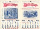
| Date: | 1895 |
|---|---|
| Description: | Catalog featuring calendar pages. The month of April features a man and a woman standing outdoors, each is playing a violin. May features a man using a hor... |

| Date: | 1882 |
|---|---|
| Description: | This pictorial bird's-eye-view map shows buildings, streets, and railroads. Included are illustrations and an index to points of interest. The bottom of th... |
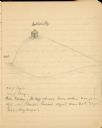
| Date: | 1897 |
|---|---|
| Description: | A pencil sketch of Butte des Morts, also called Hill of the Dead. There is a small building at the top of the hill. |

| Date: | 1857 |
|---|---|
| Description: | This map shows land ownership by name, local streets, wards, buildings, parks, a cemetery, and part of Lake Michigan. Depths are shown by soundings and nor... |
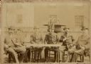
| Date: | 1885 |
|---|---|
| Description: | Six prominent German American brewers pose outdoors, seated around a table, for a portrait labeled "The Poterhouse [sic] Club." Well-dressed in suits and h... |

| Date: | 1893 |
|---|---|
| Description: | This map shows city wards, block numbers, parks, cemeteries, roads, railroads, selected buildings, and Lake Michigan. Also included are indexes to streets,... |

| Date: | 1854 |
|---|---|
| Description: | This map shows bay and harbor soundings, the Milwaukee River, and select buildings. Depths are shown by soundings and relief is shown by hachures. The top ... |

| Date: | 1857 |
|---|---|
| Description: | This map shows roads, railroads, lakes, and land ownership by name. Also included are illustrations of select business and residences, business directories... |

| Date: | 1860 |
|---|---|
| Description: | This map shows roads, railroads, rivers, townships, school houses, churches, cemeteries, and land ownership by name. Relief is shown by hachures. The map i... |

| Date: | 05 14 1886 |
|---|---|
| Description: | Printed announcement of the opening of the Madison Fire Department. At the top, in a circular frame, is a fire fighter driving a horse-drawn fire engine. B... |
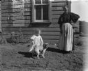
| Date: | 1898 |
|---|---|
| Description: | Exterior portrait of a woman, a small girl and a dog standing in front of a wooden building. A weathered Fourth of July poster is pasted on the side of the... |

| Date: | 01 07 1894 |
|---|---|
| Description: | Winter view of early buildings on Rocky Roost, which was west of Governor's Island. There is snow on the roofs, on the rocks and on the shore of Lake Mendo... |

| Date: | 1893 |
|---|---|
| Description: | View down pier towards the "Columbia" steamboat at the boat landing. The shoreline is the the background. There are three or four people on the steamboat a... |

| Date: | 1898 |
|---|---|
| Description: | View of a horse-drawn float decorated with banners and flags and rows of pharmaceuticals on shelves. Two costumed children are posing in the back. A large ... |

| Date: | 07 08 1896 |
|---|---|
| Description: | View down hill towards a board fence and two outbuildings on the shore of Lake Monona, taken from the back yard of the Lucius Fairchild home at 302 Monona ... |

| Date: | 1877 |
|---|---|
| Description: | This map is a photstat copy of the original and shows landownership, townships and sections, wagon roads, railroads, school houses, churches, cemeteries, m... |
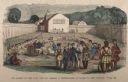
| Date: | 1859 |
|---|---|
| Description: | Hand-colored engraving showing fur company agents making a distribution of goods to Indians, some of whom are seated on the ground, in a fenced courtyard w... |
If you didn't find the material you searched for, our Library Reference Staff can help.
Call our reference desk at 608-264-6535 or email us at: