 Filter: Categories of Wisconsin Historical Images
Filter: Subject of Breweries
Filter: Year of 1800-1899
Filter: Subject of architecture
Filter: Categories of Wisconsin Historical Images
Filter: Subject of Breweries
Filter: Year of 1800-1899
Filter: Subject of architecture
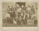
| Date: | 1870 |
|---|---|
| Description: | Group portrait of workers, a young boy and a dog outside the Schmidt and Glade Brewery posing with tools and barrels. |

| Date: | 1884 |
|---|---|
| Description: | A sign for Fauerbach's Brewery depicting a young woman and the brewery. |

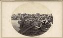
| Date: | 1898 |
|---|---|
| Description: | Bird's-eye map of Milwaukee with prominent streets and buildings identified. Taken from City Hall Tower. |

| Date: | 1882 |
|---|---|
| Description: | This map of Cedarburg is a bird's-eye map with an inset of Cedarburg Brewery. Relief is shown pictorially and the map includes an index to buildings. |

| Date: | 1878 |
|---|---|
| Description: | Bird's-eye map of Chilton with insets of points of interest, including P.H. Becker's Brewery, Chilton House, and Gutheil's Block. |

| Date: | 1880 |
|---|---|
| Description: | Bird's-eye map over the Mississippi River of Fountain City. Paddle steamers and steamboats are on the river, and bluffs are in the background. |

| Date: | 1871 |
|---|---|
| Description: | Birds eye map of Monroe, WI, depicts street names and street locations, houses, and trees. A reference key at the bottom of the map shows the locations of ... |
| Date: | 1895 |
|---|---|
| Description: | Buildings and grounds of the Leinenkugel Brewery. There are beer wagons in the yard, chickens along a wooden walkway, and men on a horse-drawn wagon near a... |
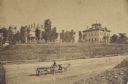
| Date: | 1862 |
|---|---|
| Description: | John S. Fuller took this image of the third Wisconsin State Capitol (the second in Madison), from Governor Farwell's Octagon House, probably early in 1862.... |
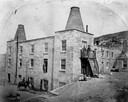
| Date: | 1860 |
|---|---|
| Description: | Exterior view of the Garden City Brewery, built in 1854. A person is on horseback in the yard below on the left, and a man is standing above them in an ope... |

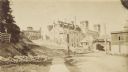
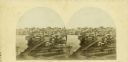
| Date: | 1870 |
|---|---|
| Description: | View from along right side of bridge of Milwaukee Street looking east in Janesville. The Myers House is located at the top of the hill. There is a sign for... |
| Date: | 1899 |
|---|---|
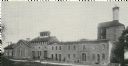
| Description: | Exterior view of the Hausmann Brewing Company's Malt House, 1603 Sherman Avenue. |
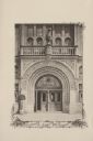
| Date: | 07 03 1886 |
|---|---|
| Description: | The ornate entrance to the Schlitz Palm Garden. Located on N. 3rd Street, south of W. Wisconsin Avenue, the Schlitz Palm Garden opened on July 3, 1886 and ... |
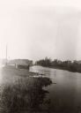
| Date: | 1897 |
|---|---|
| Description: | View along shoreline of the Yahara River, a small building along the shoreline near a road on the left. The Malt House is in the far background, prior to t... |
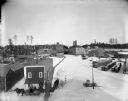
| Date: | 1870 |
|---|---|
| Description: | Large brewery in background behind railroad tracks. On the right are smaller buildings. On the left is a small hill with ladders, fences, rocks, and plant ... |
| Date: | 1876 |
|---|---|
| Description: | 462 Virginia Street. The buildings on the left are the old Melms Brewery located at the south side of the Menomonee Valley. About 1857 C.T. Melms organized... |
| Date: | 1898 |
|---|---|
| Description: | Elevated winter view of the Leinenkugel Brewery seen "from top of Mill." Originally called "Spring Brewery," Jacob Leinenkugel opened his brewery in 1867 i... |
| Date: | 1862 |
|---|---|
| Description: | The third Wisconsin State Capitol (the second in Madison), from Governor Farwell's Octagon House, probably early in 1862. Also visible in the downtown are ... |

| Date: | 1890 |
|---|---|
| Description: | A large group of Brewery workers posing outside of Gund's Brewery in La Crosse. In the front of the group two men are seated at a table with a large stein ... |

| Date: | 1859 |
|---|---|
| Description: | This map show plats including plat names, plat numbers, and some lot owner's names. Relief is shown by hachures. The map includes line drawings of Juneau B... |
If you didn't find the material you searched for, our Library Reference Staff can help.
Call our reference desk at 608-264-6535 or email us at: