 Filter: Categories of Wisconsin Historical Images
Filter: Subject of Boats and boating
Filter: Type of Map or Atlas
Filter: Subject of human settlements
Filter: Categories of Wisconsin Historical Images
Filter: Subject of Boats and boating
Filter: Type of Map or Atlas
Filter: Subject of human settlements

| Date: | 2000 |
|---|---|
| Description: | This map shows national parks, county and state forests, Indian reservations, municipal land, private land, docks, boat access, camping, and points of inte... |

| Date: | 1969 |
|---|---|
| Description: | This map shows businesses, resorts, roads, public boat landings, schools, cemeteries, and location of fish and game. An inset map reads: Continuation along... |

| Date: | 1960 |
|---|---|
| Description: | This map shows public boat ramps, parks, highways, beaches, bluffs, Green Bay, Garrett Bay, Europe Bay and Lake, Rowley's Bay and Ellison Bay. The map incl... |

| Date: | 1959 |
|---|---|
| Description: | This map shows public access sites, public beaches and parks, other public shorelines, boat liveries, public hunting and fishing grounds, railroads, roads,... |

| Date: | 1960 |
|---|---|
| Description: | This pictorial map shows recreation activities, rivers, lakes, and the history of the area. The map covers Langlade County and parts of adjacent counties. ... |

| Date: | 1960 |
|---|---|
| Description: | This map shows improved town roads, federal highways, county highways, public boat access, public hunting areas, railroads, and lakes in the area around th... |

| Date: | 1994 |
|---|---|
| Description: | This map shows historical sites, picnic grounds, public boat landings, canoe and motor boat trips, and resort locations. The left margin of the map include... |

| Date: | 2005 |
|---|---|
| Description: | This map shows dams and falls, areas of portage, canoe and kayak access, boat launches, parking, restrooms, picnic areas, dining, rapid water, parks, and b... |

| Date: | 1770 |
|---|---|
| Description: | Map of North America from the Great Lakes to the northern portion of South America. It shows cities, Native American land, mountains, swamps, lakes, rivers... |

| Date: | 1755 |
|---|---|
| Description: | Map of the northeastern portion of America and Canada, east of the Hudson River and south from Labrador. It names regions, colonies, cities, numerous forts... |

| Date: | 1935 |
|---|---|
| Description: | This colored road map comes with a map legend and explanation, as well as an index of cities and towns (and their populations) in Wisconsin. Information ab... |

| Date: | 1966 |
|---|---|
| Description: | This colored road map shows automobile roads in Wisconsin as well as portions of nearby states. Information on the quality and type of any road shown (inte... |

| Date: | 1970 |
|---|---|
| Description: | This colored map displays detailed maps of Green Bay, Appleton, Racine, Milwaukee, Kenosha, and Duluth-Superior. At the top right is a map location list of... |

| Date: | 1971 |
|---|---|
| Description: | This colored map displays Wisconsin and bordering areas of Iowa, Minnesota, and Michigan. There is color-coding on the map to indicate National Forests, an... |

| Date: | 1973 |
|---|---|
| Description: | This colored map displays Wisconsin and bordering areas of Iowa, Minnesota, and Michigan. There is color-coding on the map to indicate National Forests, a... |

| Date: | 1975 |
|---|---|
| Description: | This colored road map of Wisconsin displays "Featured Points of Interest" and "Historical Points of Interest" in the state, including three color photograp... |

| Date: | 1976 |
|---|---|
| Description: | This colored map displays Wisconsin and portions of bordering states, including a detailed map of the Wisconsin Dells area. Surrounding the map are multipl... |

| Date: | 1977 |
|---|---|
| Description: | This colored map displays Wisconsin and portions of bordering states, including a detailed map of the Wisconsin Dells area. Surrounding the map are multipl... |
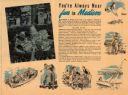
| Date: | |
|---|---|
| Description: | This map of Madison is also a brochure of activities for vacationers in the area. Includes indexes and some points of interest shown pictorially. |
If you didn't find the material you searched for, our Library Reference Staff can help.
Call our reference desk at 608-264-6535 or email us at: