 Filter: Categories of Wisconsin Historical Images
Filter: Subject of Bird's-eye views
Filter: Year of 1900-1999
Filter: County of Milwaukee
Filter: Categories of Wisconsin Historical Images
Filter: Subject of Bird's-eye views
Filter: Year of 1900-1999
Filter: County of Milwaukee
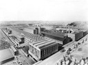
| Date: | 1910 |
|---|---|
| Description: | Birds-eye view of International Harvester's Milwaukee Works located at 1714 West Bruce Street. The factory was originally owned by the Milwaukee Harvester ... |

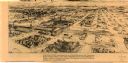
| Date: | 1906 |
|---|---|
| Description: | Bird's-eye map of South Milwaukee. |

| Date: | 1927 |
|---|---|
| Description: | Color map, hand-drawn with comic figures engaged in various activities throughout map. Bordered by the river on the left and Lake Michigan on the right, in... |

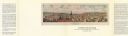
| Date: | 1937 |
|---|---|
| Description: | Bird's-eye view of Milwaukee in 1853 details building features and city layout from southwest. Important buildings are numbered in a silhouette drawing bel... |

| Date: | 1908 |
|---|---|
| Description: | Colored map in perspective indicates railroad routes. Lake Winnebago and Oshkosh in center, area extends to Shawano (top right corner), Green Bay (bottom r... |

| Date: | 1910 |
|---|---|
| Description: | Elevated view of downtown. Part of the Milwaukee River is on the left side. Sign for the Germania building is in the lower right, and city hall is in the b... |
| Date: | 1976 |
|---|---|
| Description: | Bird’s-eye-view map. Contains labeled points of interest below the map describing the buildings and streets. Caption below the map reads: "CITIES ON STONE ... |
| Date: | 1977 |
|---|---|
| Description: | This map is a bird’s-eye-view of South Milwaukee reproduced in the Oak Creek Pictorial of July 6, 1977. The map was originally published in an unidentified... |
If you didn't find the material you searched for, our Library Reference Staff can help.
Call our reference desk at 608-264-6535 or email us at: