Filter: Categories of Wisconsin Historical Images
Filter: Subject of Bears
Filter: Subject of men
Filter: Subject of bears
Filter: Categories of Wisconsin Historical Images
Filter: Subject of Bears
Filter: Subject of men
Filter: Subject of bears
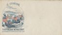
| Date: | 11 08 1906 |
|---|---|
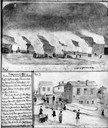
| Description: | Two Civil War watercolor drawings by John Gaddis, Company E, 12th Wisconsin Volunteer Infantry, showing the regiment in bivouac, and later their headquarte... |
| Date: | 06 03 1931 |
|---|---|
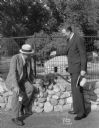
| Description: | Jim McWilliams, "Pianutist" vaudeville actor, and Fred Winklemann, Zoo director, with the Mexican Snookum bear (coati), at Vilas Zoo (Vilas Park Zoo). |
| Date: | 1844 |
|---|---|
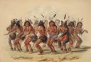
| Description: | Indian dance, with some wearing bear masks (Plate 18). "Next in importance to the buffalo hunts, and not less exciting and spirited in its character, is ... |
| Date: | 1844 |
|---|---|
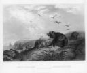
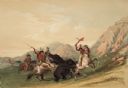
| Description: | Indians on horseback trying to kill a bear (Plate 19). "The preliminaries of the hunt for the Grizzly Bear having been settled in the manner described in... |
| Date: | 1950 |
|---|---|
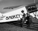
| Description: | Smokey Bear cub and his handler, Homer C. Pickens, pose by a Piper Aircraft Corporation airplane named in Smokey's honor prior to flying to Washington, D.C... |
| Date: | 1836 |
|---|---|
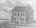
| Description: | Drawing of the Solomon Juneau house on East Michigan. There are tethered bears on either side of the front door. Two people are leaning on the fence, watch... |
| Date: | |
|---|---|
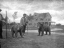
| Description: | View of two men with two bears on leashes standing on a lawn. The bears are wearing muzzles and the men have staves. A large house is in the background. |
| Date: | 1860 |
|---|---|
| Description: | A circus traveling on the road has three cages, the first and second are flying the Confederate flag. A stone at the side of the road says "TO BOSTON." "T... |
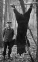
| Date: | |
|---|---|
| Description: | A hunter poses with a large bear hainging in a wooded area at Lone Pine Camp. His rifle leans against the bear. |

| Date: | 1930 |
|---|---|
| Description: | Pictorial map of Glacier National Park, Montana and Waterton Lakes National Park, Alberta. Illustrated by Joe Scheurle, it depicts white people, American ... |
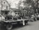
| Date: | 1950 |
|---|---|
| Description: | Bernard Arms holding a firearm poses on a parade float decorated in an autumn theme, including a stuffed bear, fox, and squirrel. The parade was a part of ... |
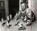
| Date: | 08 12 1960 |
|---|---|
| Description: | Walter Lofblad, a Cumberland farmer, with miniature Milwaukee Braves figures he carved from basswood. The carved set includes the entire starting lineup, m... |
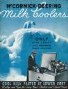
| Date: | 1938 |
|---|---|
| Description: | Cover of an advertising brochure for McCormick-Deering Milk Coolers. Features a color illustration of a polar bear on an iceberg and a photo of a man putti... |

| Date: | 1978 |
|---|---|
| Description: | Wisconsin Congressman David R. Obey with pre-schoolers and their teacher at Ellis School, a program supported in part by Title I federal funding. Throughou... |

| Date: | 1950 |
|---|---|
| Description: | Photographic postcard of a man holding a rifle, squatting on ground on the right, with his trophies: Carcasses of a deer, a bear and a wolf hanging from pi... |
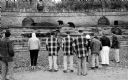
| Date: | 10 20 1961 |
|---|---|
| Description: | Several men and women patients from Mendota State Hospital are watching the bears at the Vilas Park Zoo. A volunteer took them for the outing in her person... |

| Date: | 1758 |
|---|---|
| Description: | This map of the north-west hemisphere shows the cities, lakes, rivers, mountains, and political borders. In the upper left corner sits a decorative cartouc... |

| Date: | 1636 |
|---|---|
| Description: | Map of North America, divided into regions, and showing some rivers, lakes, settlements, cities, mountains, and Native American land. Of the Great Lakes on... |

| Date: | 1766 |
|---|---|
| Description: | This map of North America shows the boundaries of European claims at the end of the French and Indian war. The British colonies extend to the Mississippi. ... |
If you didn't find the material you searched for, our Library Reference Staff can help.
Call our reference desk at 608-264-6535 or email us at: