 Filter: Categories of Wisconsin Historical Images
Filter: Subject of Bays
Filter: Subject of signs and symbols
Filter: Categories of Wisconsin Historical Images
Filter: Subject of Bays
Filter: Subject of signs and symbols

| Date: | 1893 |
|---|---|
| Description: | Bird's-eye map of Sturgeon Bay, looking Northeast. Area bordered by Church Street in top left corner, leather & Smith Bridge in bottom left corner, Lawrenc... |
| Date: | 1931 |
|---|---|
| Description: | View of the Radisson-Groseilliers house historic site marker in the vicinity of Ashland. The marker was unveiled at the mouth of Fish Creek on October 25, ... |
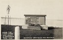
| Date: | 1944 |
|---|---|
| Description: | View of the Radisson and Groseilliers marker at the site of the first house built by white men in Wisconsin. The marker is located in the vicinity of Ashla... |

| Date: | 1894 |
|---|---|
| Description: | This map shows lot and block numbers, railroads, street car tracks, sewers, water mains, gas mains, paved streets, land owned by the Land & River Improveme... |
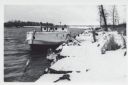
| Date: | 01 06 1958 |
|---|---|
| Description: | View from snowy shoreline of Mooring Basin at bay end of Ship Canal. The boat moored in the foreground is named "Allie." It is tethered to a post on the sh... |
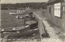
| Date: | |
|---|---|
| Description: | View across water towards a group of people, men, woman, and young girls and boys, posing on a pier in front of a building on the shoreline of Sister Bay. ... |

| Date: | 1667 |
|---|---|
| Description: | Map of Virginia depicting the discoveries detailed by John Smith in his exploration of the region. It shows Jamestown, Native American tribes and villages,... |

| Date: | 1671 |
|---|---|
| Description: | Map of Virginia depicting the discoveries detailed by John Smith in his exploration of the region. It shows Jamestown, Native American tribes and villages,... |
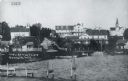
| Date: | 1915 |
|---|---|
| Description: | View of Ephraim from the bay, with a pier in the foreground. Churches are on the left and right, and the Hillside Hotel is in the center near the shore. Ca... |
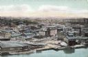
| Date: | |
|---|---|
| Description: | Aerial view of Green Bay from the bay. Commercial and industrial buildings are in the foreground. Waterfront businesses include F. Hurlbut Cement and W.W. ... |

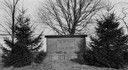
| Date: | |
|---|---|
| Description: | View of Anderson Dock through trees from the shoreline. Graffiti, covers the building. |

| Date: | 1940 |
|---|---|
| Description: | A woman wearing a bandana on her head is sitting at a picnic table talking with another woman who is standing in front of a tent-style camping trailer. Bot... |
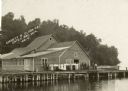
| Date: | 1940 |
|---|---|
| Description: | Text on front reads: "Scene at Kellstrom's Dock, Sister Bay, Wis." View of Sister Bay from a boathouse and dock, the sign reads: "Kellstrom's Fishing Trips... |
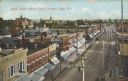
| Date: | 07 21 1908 |
|---|---|
| Description: | Text on front reads: "Cedar Street looking South, Sturgeon Bay, Wis." Elevated view of storefronts on a street, the west facing stores all have awnings. A ... |
If you didn't find the material you searched for, our Library Reference Staff can help.
Call our reference desk at 608-264-6535 or email us at: