 Filter: Categories of Wisconsin Historical Images
Filter: Subject of Bays
Filter: Subject of bays
Filter: Subject of dwellings
Filter: Categories of Wisconsin Historical Images
Filter: Subject of Bays
Filter: Subject of bays
Filter: Subject of dwellings

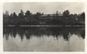
| Date: | 1904 |
|---|---|
| Description: | Monona Bay from the railroad trestle looking southwest, close to where the railroad tracks cross North Shore Drive, (now Brittingham Park), with old houses... |
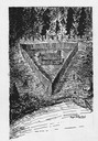
| Date: | 1655 |
|---|---|
| Description: | Front view of the Radisson cabin, the first house built by a white man in Wisconsin. It was built between 1650 and 1660 on Chequamegon Bay, in the vicinity... |

| Date: | 1915 |
|---|---|
| Description: | View from hill across Eagle Bay with buildings and trees in the foreground. Caption reads: "Across Eagle Bay, Ephraim, Wis." |

| Date: | 1910 |
|---|---|
| Description: | View from hill towards downtown Fish Creek, with the buildings and ground covered in snow. There is a road in the foreground leading off to the left. The b... |
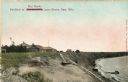
| Date: | 1910 |
|---|---|
| Description: | Walkway on the bluff leading down to a pavilion on the shoreline. Houses are in the background. Caption reads: "Pavilion at Bendersville, near Green Bay, W... |
| Date: | 1937 |
|---|---|
| Description: | View down the hill toward the U.S. Coast Guard Station on the left with two communications towers on the Lake Michigan shoreline. Railroad tracks are just ... |
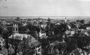
| Date: | |
|---|---|
| Description: | Elevated view looking down on the town with the bay and opposite shoreline in distance. |

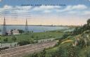
| Date: | 1941 |
|---|---|
| Description: | Elevated view of Sturgeon Bay in 1900. Sturgeon Bay Bridge spans the bay and several boats are on the water. A lighthouse sits on a small island in the bay... |
| Date: | |
|---|---|
| Description: | View over water of Main Lodge as seen from boat on bay. Original caption notes: "It fits well into the landscape and seems to have been there always. Forty... |

| Date: | 1909 |
|---|---|
| Description: | This map shows vacant Wisconsin Central Ry. lands, settlers houses, lands sold by Wisconsin Central Ry., schools, churches, saw mills, and roads; also show... |
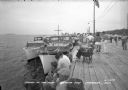
| Date: | 1940 |
|---|---|
| Description: | View of a crowd gathered along a pier for Regatta Day. Boats are docked alongside the pier on the left. |
| Date: | 1910 |
|---|---|
| Description: | View along shoreline of Weborg Point before the area became Peninsula State Park. Green Bay is on the left. Two wood buildings are along the shoreline in t... |
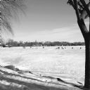
| Date: | 01 2014 |
|---|---|
| Description: | View from shoreline on a sunny day of snow-covered, frozen Monona Bay. People in the distance are standing or sitting near ice fishing holes and ice fishin... |
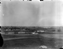
| Date: | |
|---|---|
| Description: | View from University Heights looking south across open fields towards barns and fences. (written on envelope: Camp Randall, Old Dane Country Fair Grounds).... |
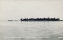
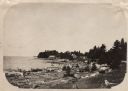
| Date: | |
|---|---|
| Description: | View across water towards Little Strawberry Island in Green Bay. The beach on the left side of the island is sandy, and a house can be seen among the trees... |
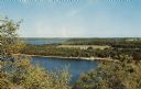
| Date: | 1957 |
|---|---|
| Description: | Elevated view of Little Sister Bay and the surrounding landscape. |

| Date: | 1667 |
|---|---|
| Description: | Map of Virginia depicting the discoveries detailed by John Smith in his exploration of the region. It shows Jamestown, Native American tribes and villages,... |

| Date: | 1776 |
|---|---|
| Description: | Map of Virginia and parts of Maryland and Delaware (written "De La War"). It shows borders, counties, cities, towns, plantations (marked by landowners name... |
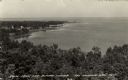
| Date: | |
|---|---|
| Description: | Elevated view of Green Bay from the Alpine Tower at Egg Harbor. A few dwellings are along the shoreline on the left. Caption reads: "View from the Alpine T... |
If you didn't find the material you searched for, our Library Reference Staff can help.
Call our reference desk at 608-264-6535 or email us at:
