 Filter: Categories of Wisconsin Historical Images
Filter: Subject of Battles
Filter: Subject of military art and science
Filter: Categories of Wisconsin Historical Images
Filter: Subject of Battles
Filter: Subject of military art and science
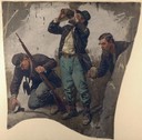
| Date: | 1886 |
|---|---|
| Description: | Oil on linen study of three Union Civil War soldiers drinking from and holding canteens. The painting is the work of one of the German panorama artists ac... |

| Date: | |
|---|---|
| Description: | Poster of woman and child that says "Remember Wounded Knee". |

| Date: | |
|---|---|
| Description: | A lithograph titled "Charge of the 15th Wisconsin Regiment at Chickamauga; death of Colonel Heg," showing the death of Hans Christian Heg. |
| Date: | 1862 |
|---|---|
| Description: | This pen and ink drawing of the First Battle of Bull Run, JuIy 21st, 1861, was made by Charles K. Dean, adjutant with the 2nd Wisconsin Infantry. The 2nd W... |

| Date: | 1863 |
|---|---|
| Description: | This map is a hand-colored, pen and ink, drawing by Ole R. Dahl of Co. B, 15 Wisconsin Infantry shows the battlefield at Stones River, depicting roads, str... |

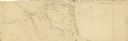
| Date: | 1863 |
|---|---|
| Description: | These detailed topographical maps of the Battle of Gettysburg show drainage, vegetation, roads, railroads, fences, houses with names of residents, and a de... |

| Date: | 1863 |
|---|---|
| Description: | A general map of the southeastern United States showing Missouri, Kentucky, West Virginia, Virginia, North Carolina, South Carolina, Georgia, Florida, Alab... |

| Date: | 1862 |
|---|---|
| Description: | This map consists of four separate panels. The first illustrates the battlefield at Cedar Mountain on Aug. 9, 1862, where the 3rd Wisconsin Infantry fought... |

| Date: | 1862 |
|---|---|
| Description: | This map shows the plan of the siege of Yorktown and the Battle of Williamsburg. The map also shows fortifications, towns, roads, houses, names of resident... |
| Date: | 1940 |
|---|---|
| Description: | This map, oriented with north to the right, shows troop disposition and movements, including encampments, unit locations, lines of march, and lines of enem... |
| Date: | 1915 |
|---|---|
| Description: | Austrian field artillery piece in Galicia at the moment of firing with the recoil of the firing tube blurred from movement. |

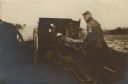
| Date: | 09 28 1914 |
|---|---|
| Description: | Town of Saales. Bombarded by the French on September 28. |
If you didn't find the material you searched for, our Library Reference Staff can help.
Call our reference desk at 608-264-6535 or email us at: