 Filter: Categories of Wisconsin Historical Images
Filter: Subject of Battles
Filter: Type of Map or Atlas
Filter: Subject of cities and towns
Filter: Categories of Wisconsin Historical Images
Filter: Subject of Battles
Filter: Type of Map or Atlas
Filter: Subject of cities and towns

| Date: | 1865 |
|---|---|
| Description: | This detailed map of the area between Richmond and Petersburg shows fortifications, roads, railroads, towns, street patterns of Petersburg and Richmond, dr... |
| Date: | 1865 |
|---|---|
| Description: | This map shows the seven raids made in central Virginia by cavalry under the command of Maj. Gen. Philip H. Sheridan between May 9, 1864, and May 3, 1865. |

| Date: | 1867 |
|---|---|
| Description: | This map of the battlefield on the North Anna River at Hanover Junction illustrates the Union positions in blue and Confederate positions in red. Roads, ra... |
| Date: | |
|---|---|
| Description: | Pen and ink tracing by Lt. Napoleon Boardman of the 2nd Wisconsin Cavalry, is colored to show positions of forces and depicts the positions of Union and Co... |
| Date: | |
|---|---|
| Description: | Map prepared by John B. Tripp (1843-1933), a musician serving in Company A of the 32nd Wisconsin Infantry, shows the route taken by the 32nd between Nov. 1... |

| Date: | |
|---|---|
| Description: | Pen and ink tracing showing the positions of Union and Confederate soldiers, troop camps, location of graves, roads, drainage, vegetation, houses, and fenc... |

| Date: | 1865 |
|---|---|
| Description: | The map of the battlefield shows entrenchments, villages, roads, the "South Side Rail Road" drainage, vegetation, relief by hachures, houses, and names of ... |

| Date: | 1862 |
|---|---|
| Description: | This map consists of four separate panels. The first illustrates the battlefield at Cedar Mountain on Aug. 9, 1862, where the 3rd Wisconsin Infantry fought... |

| Date: | 1865 |
|---|---|
| Description: | This map illustrates the lines of defense established by Confederate troops, under the command of General Joseph E. Johnston, at Raleigh, North Carolina, i... |

| Date: | |
|---|---|
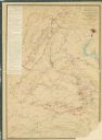
| Description: | This detailed map shows fortifications, headquarters, location and dates of battles, street outline of Atlanta, roads, railroads, vegetation, drainage, rel... |

| Date: | 1862 |
|---|---|
| Description: | This detailed map shows batteries and rifle pits, railroads, common and military roads, turnpikes, city streets and names, bridges, ferries, rural houses a... |

| Date: | |
|---|---|
| Description: | A map of southern Wisconsin and northern Illinois showing where the battles took place and routes taken by Black Hawk and his band during the Black Hawk Wa... |

| Date: | 05 01 1899 |
|---|---|
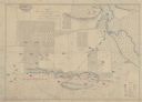
| Description: | Map showing the Schuylkill River with roads, ferries, and points of interest from Valley Forge to Philadelphia, Pennsylvania as it appeared during the Revo... |

| Date: | 1865 |
|---|---|
| Description: | This map shows U.S. cavalry positions in yellow, Confederate infantry positions in blue, and Confederate cavalry positions in red. The map also shows roads... |
| Date: | 1940 |
|---|---|
| Description: | This map, oriented with north to the right, shows troop disposition and movements, including encampments, unit locations, lines of march, and lines of enem... |

| Date: | 1777 |
|---|---|
| Description: | Map showing the Hudson River in three sections, from New York City up through Lake Champlain, including cities, forts, roads, topographical features, and n... |

| Date: | 1733 |
|---|---|
| Description: | This map of North America shows settlements, rivers, lakes, Native American land, trade winds, and numerous topographical features such as forests and moun... |

| Date: | 1770 |
|---|---|
| Description: | Map of North America from the Great Lakes to the northern portion of South America. It shows cities, Native American land, mountains, swamps, lakes, rivers... |

| Date: | 1767 |
|---|---|
| Description: | Map of the north east coast of America, showing colonial borders, cities, Native American land, lakes, rivers, and a few hills and mountains. Illustrated t... |

| Date: | 1777 |
|---|---|
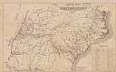
| Description: | Map of Colonial America east of Lake Michigan showing regions, cities, forts, Native American land, mountains, lakes, and rivers. Crossed swords and small ... |
If you didn't find the material you searched for, our Library Reference Staff can help.
Call our reference desk at 608-264-6535 or email us at: