 Filter: Categories of Wisconsin Historical Images
Filter: Subject of Attractions
Filter: Subject of transportation
Filter: Categories of Wisconsin Historical Images
Filter: Subject of Attractions
Filter: Subject of transportation

| Date: | 1934 |
|---|---|
| Description: | This map shows the area as it appeared in 1848 and includes buildings, land use, and roads with distances to nearby locations. The upper right corner reads... |
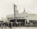
| Date: | 1940 |
|---|---|
| Description: | Exterior view of the entrance to the McCormick-Deering, International tent at the Minnesota State Fair. A group of people are gathered in front of the entr... |

| Date: | |
|---|---|
| Description: | A woman stands next to a locomotive on display behind a fence at House on the Rock. This image was included in the attraction's brochure. The sign on the t... |

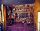
| Date: | |
|---|---|
| Description: | The Streets of Yesterday, a nostalgic faux downtown, on exhibit at House on the Rock. This photograph was used in the original brochure for House on the Ro... |
| Date: | |
|---|---|
| Description: | The Pontalba Hearse, made of carved wood displayed behind a fence. This image was used in the original brochure for the House on the Rock. |
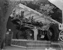
| Date: | |
|---|---|
| Description: | Peter Burno posing with the steam locomotive he built which is on display behind a fence at House on the Rock. The sign above the train reads: "Peter H. Bu... |
| Date: | |
|---|---|
| Description: | A man posing with a locomotive on display behind a fence at House on the Rock. The sign on the train reads: "Peter H. Burno. Mighty in Strength & Endurance... |

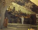
| Date: | |
|---|---|
| Description: | View of "Streets of Yesterday" at House on the Rock. |

| Date: | 1936 |
|---|---|
| Description: | This colored road map shows automobile roads in Wisconsin as well as portions of nearby states. Information on the quality and type of any given road (pave... |

| Date: | 1937 |
|---|---|
| Description: | This blue-line map of Wisconsin shows two maps of Wisconsin and the surrounding area, with a railroad map on one side and a road map on the other. The rail... |

| Date: | 1966 |
|---|---|
| Description: | This colored road map shows automobile roads in Wisconsin as well as portions of nearby states. A map key indicates relative sizes of cities and towns. On ... |

| Date: | 1967 |
|---|---|
| Description: | This colored map published by the State Historical Society of Wisconsin shows key points of interest telling the story of Wisconsin's earliest settlement a... |

| Date: | 1970 |
|---|---|
| Description: | This colored map displays a brief description of tourist attractions in the state, as well as a grid of state parks and recreational facilities. There is a... |

| Date: | 1966 |
|---|---|
| Description: | This colored road map shows automobile roads in Wisconsin as well as portions of nearby states. Information on the quality and type of any road shown (inte... |

| Date: | 1971 |
|---|---|
| Description: | This colored map displays Wisconsin and bordering areas of Iowa, Minnesota, and Michigan. There is color-coding on the map to indicate National Forests, an... |

| Date: | 1973 |
|---|---|
| Description: | This colored map displays Wisconsin and bordering areas of Iowa, Minnesota, and Michigan. There is color-coding on the map to indicate National Forests, a... |

| Date: | 1975 |
|---|---|
| Description: | This colored road map of Wisconsin displays "Featured Points of Interest" and "Historical Points of Interest" in the state, including three color photograp... |

| Date: | 1973 |
|---|---|
| Description: | This map displays, in color, Wisconsin and bordering areas of Iowa, Minnesota, Illinois, and Michigan. At the bottom is a map key indicating road classifi... |

| Date: | 1976 |
|---|---|
| Description: | This color map displays Wisconsin and bordering areas of Iowa, Minnesota, Illinois, and Michigan. At the bottom is a map key indicating road classification... |

| Date: | 1976 |
|---|---|
| Description: | This colored map displays Wisconsin and portions of bordering states, including a detailed map of the Wisconsin Dells area. Surrounding the map are multipl... |
If you didn't find the material you searched for, our Library Reference Staff can help.
Call our reference desk at 608-264-6535 or email us at: