Filter: Categories of Wisconsin Historical Images
Filter: Subject of Apostle Islands
Filter: Subject of human settlements
Filter: Categories of Wisconsin Historical Images
Filter: Subject of Apostle Islands
Filter: Subject of human settlements

| Date: | 1886 |
|---|---|
| Description: | Bird's-eye view of Ashland, on the shores of Lake Superior, with insets of The Apostle Islands Chequamagon Bay & Ashland, and Distances from Ashland. |

| Date: | 1886 |
|---|---|
| Description: | Bird's-eye view of Bayfield, county seat of Bayfield County. On the lower left side is an inset for Bayfield and the Apostle Islands. |

| Date: | 1886 |
|---|---|
| Description: | Bird's-eye map of Washburn on Lake Superior. There is an inset of Washburn, Chequamagon and the Apostle Islands. |

| Date: | 02 26 1887 |
|---|---|
| Description: | Bird's-eye map of Ashland, and the Apostle Islands in Lake Superior. Caption reads: "Ashland and the Apostle Islands." |
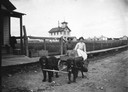
| Date: | 1910 |
|---|---|
| Description: | Two women sitting in dog cart on dirt street in front of boardwalk. La Pointe Village School is in the background. Dog team belongs to Tom Stahl. |
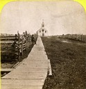
| Date: | 1870 |
|---|---|
| Description: | Boardwalk leading to St. Joseph's Catholic Church in La Pointe. |

| Date: | 1884 |
|---|---|
| Description: | Panorama bird's-eye view of the town of Ashland, on Lake Superior, and the Apostle Islands. |

| Date: | 1905 |
|---|---|
| Description: | Camp Stella looking south toward the Bayfield County shoreline from an Apostle Island. |
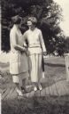
| Date: | 1912 |
|---|---|
| Description: | Two young women standing on a boardwalk on Madeline Island. |

| Date: | 1878 |
|---|---|
| Description: | A color map detailing Ashland and Bayfield counties, including Lake Superior and the Apostle Islands. |
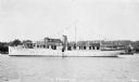
| Date: | 1933 |
|---|---|
| Description: | View across water of the motor yacht "The Nellewood" at dock at Madeline Island on Lake Superior. A group of passengers sit in the bow area. The "Nellewood... |
| Date: | 1935 |
|---|---|
| Description: | Ojibwe wooden burial houses surrounded by wooden fence on Madeline Island. Two women stand in the background. |
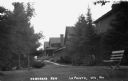
| Date: | 1938 |
|---|---|
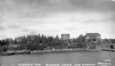
| Description: | Large vacation homes in La Pointe, Madeline Island. Bayfield is in the background on the far shore of Lake Superior. |
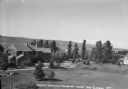
| Date: | 1937 |
|---|---|
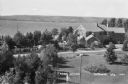
| Description: | Sidewalk in front of four houses along Nebraska Row at Madeline Island. Nebraska Row was started by Col. Frederick Woods in 1899 on the bluff at the wester... |
| Date: | 1937 |
|---|---|
| Description: | View from lake of the summer homes on Nebraska Row along the shoreline of Lake Superior. |
| Date: | 1937 |
|---|---|
| Description: | Elevated view of a woman standing on lawn of the Woods mansion on Nebraska Row. Bayfield is visible on the opposite mainland shore of Lake Superior. |

| Date: | 09 24 1910 |
|---|---|
| Description: | View of several fisherman's homes on Bear Island, one of the islands that make up the Apostle Islands. An American flag is flying between buildings and a d... |
| Date: | |
|---|---|
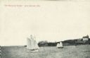
| Description: | View across water towards two schooners off the shore of Madeline Island, one of the islands that comprise the Apostle Islands in Lake Superior. Two large ... |

| Date: | 1884 |
|---|---|
| Description: | A detailed, hand-colored map of Wisconsin and the western portion of Michigan’s Upper Peninsula, which also includes an inset of Isle Royale in Lake Superi... |
If you didn't find the material you searched for, our Library Reference Staff can help.
Call our reference desk at 608-264-6535 or email us at: