 Filter: Categories of Wisconsin Historical Images
Filter: Subject of Apostle Islands
Filter: County of Ashland
Filter: Subject of cities and towns
Filter: Categories of Wisconsin Historical Images
Filter: Subject of Apostle Islands
Filter: County of Ashland
Filter: Subject of cities and towns

| Date: | 1886 |
|---|---|
| Description: | Bird's-eye view of Ashland, on the shores of Lake Superior, with insets of The Apostle Islands Chequamagon Bay & Ashland, and Distances from Ashland. |

| Date: | 02 26 1887 |
|---|---|
| Description: | Bird's-eye map of Ashland, and the Apostle Islands in Lake Superior. Caption reads: "Ashland and the Apostle Islands." |

| Date: | 1884 |
|---|---|
| Description: | Panorama bird's-eye view of the town of Ashland, on Lake Superior, and the Apostle Islands. |
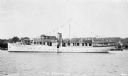
| Date: | 1933 |
|---|---|
| Description: | View across water of the motor yacht "The Nellewood" at dock at Madeline Island on Lake Superior. A group of passengers sit in the bow area. The "Nellewood... |
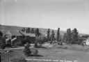
| Date: | 1938 |
|---|---|
| Description: | Large vacation homes in La Pointe, Madeline Island. Bayfield is in the background on the far shore of Lake Superior. |
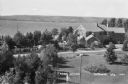
| Date: | 1937 |
|---|---|
| Description: | Elevated view of a woman standing on lawn of the Woods mansion on Nebraska Row. Bayfield is visible on the opposite mainland shore of Lake Superior. |

| Date: | 1990 |
|---|---|
| Description: | This tourism brochure of Ashland County, Wisconsin, from the Ashland Area Chamber of Commerce includes a map of the county showing tourist destinations and... |

| Date: | 1900 |
|---|---|
| Description: | This chart of the northern Apostle Islands and Lake Superior shoreline shows relief by contours and spot heights and depths by contours, gradient tints and... |
If you didn't find the material you searched for, our Library Reference Staff can help.
Call our reference desk at 608-264-6535 or email us at: