 Filter: Categories of Wisconsin Historical Images
Filter: Subject of Agriculture
Filter: Subject of social issues
Filter: Subject of water
Filter: Categories of Wisconsin Historical Images
Filter: Subject of Agriculture
Filter: Subject of social issues
Filter: Subject of water
| Date: | |
|---|---|
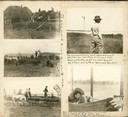
| Description: | A scrapbook page containing five photographs of John R. Commons and farm labor. The handwriting in the center reads: "Dale Farm with AL and Windy." Caption... |

| Date: | |
|---|---|
| Description: | A group of men and boys pose by a pond. A boy holds a long, probably bamboo, fishing rod. Two men jokingly pose as if they are dancing the tango. |
| Date: | 1889 |
|---|---|
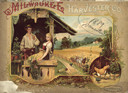
| Description: | Front cover featuring an illustration of a man and a woman relaxing on a porch. In the background on the right a team of horses are harnessed to a Milwauke... |

| Date: | 1770 |
|---|---|
| Description: | The south west sheet of a four sheet map of Virginia, showing the counties, mountains, rivers, court houses, a few cities, and mills. A few Plantations ar... |

| Date: | 1780 |
|---|---|
| Description: | This map shows the townships, parishes, cities, towns, plantations, lakes, rivers, swamps, and roads near the coast of South Carolina and Georgia. Emphasis... |

| Date: | 1755 |
|---|---|
| Description: | Map of Virginia and parts of Maryland, North Carolina, and New Jersey. It shows borders, boundary lines, some Native American land, counties, cities, towns... |
If you didn't find the material you searched for, our Library Reference Staff can help.
Call our reference desk at 608-264-6535 or email us at: