 Filter: Categories of Wisconsin Historical Images
Filter: Subject of Agriculture
Filter: Subject of ocean
Filter: Categories of Wisconsin Historical Images
Filter: Subject of Agriculture
Filter: Subject of ocean
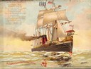
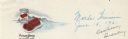
| Date: | 1897 |
|---|---|
| Description: | Color lithograph cover illustration for the McCormick Harvesting Machine Company catalog. Shows a steam powered sailing ship named "Progress" with a McCorm... |

| Date: | 1893 |
|---|---|
| Description: | Front and back covers of an advertising brochure for the New Empire line of mowers, reapers and grain binders manufactured by J.F. Seiberling & Company. Th... |
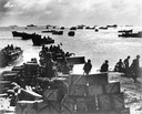
| Date: | 1944 |
|---|---|
| Description: | Original caption reads: "Coast guardsmen shuttle landing craft back and forth from the anchorage to the beach of Eniwetok Atoll, bringing in fighters and s... |

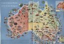
| Date: | 1938 |
|---|---|
| Description: | A colorful pictorial map of Australia, featured on the front and back cover of a special Australian edition of International Trail. |

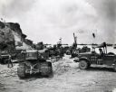
| Date: | 1945 |
|---|---|
| Description: | Marines use an International TD-9 crawler tractor (TracTracTor) and dozer shovel loader to unload supplies on a beach. A ship is in the background. The ori... |

| Date: | 1945 |
|---|---|
| Description: | Marines use an International TD-9 crawler tractor (TracTracTor) with a dozer shovel loader to fill a truck parked on a beach. A ship is in the water behind... |
| Date: | 1945 |
|---|---|
| Description: | Marines use an International TD-18 Diesel crawler tractor (TracTracTor) to unload supplies and equipment from a ship. Many ships are in the water in the ba... |
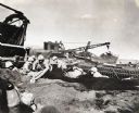
| Date: | 1945 |
|---|---|
| Description: | Marines dig foxholes into the sand on the beaches of Iwo Jima. The men are surrounded by military equipment, including a crane. An International Diesel cra... |

| Date: | 1918 |
|---|---|
| Description: | Emergency label for Ocean View Early June Peas printed over an unused wax beans label. The label shows a bowl of cut wax beans on one side and a view of th... |

| Date: | |
|---|---|
| Description: | Elevated view of grid-plotted farm fields with a few cows grazing. The ocean is visible in the background. |
| Date: | |
|---|---|
| Description: | Letterhead of the Ocean Spray brand of cranberries, with a can of jellied cranberry sauce and a serving dish with the sauce retaining the shape of its can ... |
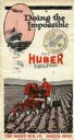
| Date: | 1920 |
|---|---|
| Description: | Front cover of a pamphlet advertising the Huber Light Four tractor, featuring text reading: "Doing the Impossible." Includes an illustration of a farmer dr... |

| Date: | 1952 |
|---|---|
| Description: | Map of the barley-growing regions of North America, published by the Rahr Malting Company, Manitowoc, Wisconsin, 1952. |

| Date: | 1625 |
|---|---|
| Description: | An illustrated map of the world with captions in Latin. Illustrations include depictions of the seasons and the elements. |

| Date: | |
|---|---|
| Description: | Front cover and partial menu listing with drinks overleaf. Front cover has a porthole view of pairs of men in three boats with mountains and palm trees in ... |
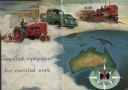
| Date: | 1955 |
|---|---|
| Description: | Men are driving International Harvester tractor, truck and crawler in a cloud above the continent of Australia. The IH logo is at the bottom right in a com... |
| Date: | 1950 |
|---|---|
| Description: | Color illustrated map of Australia shows various resources available in the different regions of Australia. Original caption: "Australia is the the mi... |

| Date: | 1946 |
|---|---|
| Description: | This bird's-eye-view map shows scenes of land use and farming superimposed on a map of the United States. Agricultural scenes of farming, livestock, and cr... |

| Date: | 1942 |
|---|---|
| Description: | This pictorial bird's-eye-view map shows the United States of America with parts of Canada and Mexico. Landscape, trade, industry, points of interest, peop... |

| Date: | 1780 |
|---|---|
| Description: | This map shows the townships, parishes, cities, towns, plantations, lakes, rivers, swamps, and roads near the coast of South Carolina and Georgia. Emphasis... |
If you didn't find the material you searched for, our Library Reference Staff can help.
Call our reference desk at 608-264-6535 or email us at: