 Filter: Categories of Wisconsin Historical Images
Filter: Subject of Agriculture
Filter: Subject of fortification
Filter: Categories of Wisconsin Historical Images
Filter: Subject of Agriculture
Filter: Subject of fortification

| Date: | 09 10 1875 |
|---|---|
| Description: | View looking west across the area once occupied by Camp Randall during the Civil War and towards the Breese Stevens farm property. The Madison Centennial ... |
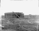
| Date: | 1898 |
|---|---|
| Description: | Ruins of the commissary warehouse at Fort Winnebago, about 1898. Fort Winnebago was closed in 1845 and the land and buildings sold. Today, only the Surgeon... |
| Date: | 1860 |
|---|---|
| Description: | Scene of 16 figures. A slave owner is raising his whip as black families are racing towards Fort Monroe, with some remaining behind picking cotton. The sla... |

| Date: | |
|---|---|
| Description: | Men work outside dwellings along a shoreline in a reproduction of a painting by W.L. Williams. Copyright by A.S. Burbank, 1891. |

| Date: | 1816 |
|---|---|
| Description: | This is a photostat copy of a manuscript map in the National Archives showing a plan of Fort Howard and a view of its north side. Originally surveyed by Wi... |
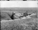
| Date: | 1918 |
|---|---|
| Description: | Two British soldiers posing in a trench. The soldier on the right is manning an air-cooled Vickers light machine gun, and the soldier on the left is holdin... |
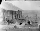
| Date: | 1918 |
|---|---|
| Description: | Two soldiers outside of a trench that is next to a log cabin which is reinforced with sandbags. One of the soldiers appears to be preparing a meal in an ou... |
| Date: | 1918 |
|---|---|
| Description: | View of field with a damaged blockhouse constructed of logs, and a smaller outbuilding in the distance. It appears the roof of the fortification has sustai... |
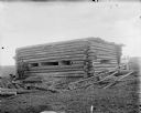
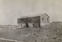
| Date: | 1918 |
|---|---|
| Description: | A damaged blockhouse constructed with logs. In the distance are more buildings. It appears the roof of the fortification has sustained some damage and logs... |

| Date: | 1900 |
|---|---|
| Description: | This photostat of a manuscript map originally drawn in 1829 shows landownership, buildings, including Fort Howard and U.S. sawmill, swamps, public barns an... |

| Date: | 1862 |
|---|---|
| Description: | This map shows landownership on a military reserve, private claims, buildings (including Fort Howard and U.S. sawmill), swamps, public barns and fields, an... |

| Date: | 03 1777 |
|---|---|
| Description: | Map showing the British and Hessian attack on Fort Washington in November of 1776. The movements and fortifications of the British and Hessian troops appea... |

| Date: | 1776 |
|---|---|
| Description: | Fairly detailed map of New York City and parts of Long Island. It shows streets, roads, wharves, ferries, ship yards, Fort George and the battery, public b... |
If you didn't find the material you searched for, our Library Reference Staff can help.
Call our reference desk at 608-264-6535 or email us at: