Filter: Categories of Wisconsin Historical Images
Filter: Subject of Aerial photographs
Filter: Subject of transportation
Filter: Categories of Wisconsin Historical Images
Filter: Subject of Aerial photographs
Filter: Subject of transportation
| Date: | 1912 |
|---|---|
| Description: | Cicero Field, the airfield operated by the Aero Club of Illinois, as photographed by DeLloyd Thompson from a Wright plane that was piloted by Jesse Brabazo... |
| Date: | 1988 |
|---|---|
| Description: | Aerial view of the 1988 EAA (Experimental Aviation Association) Convention and Fly-in at Wittman Field. On the ground is the Concorde and a B-1 Bomber. |
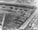
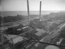
| Date: | 1911 |
|---|---|
| Description: | International Harvester's McCormick Works on the river with railroad tracks and a cargo dock. The factory was owned by the McCormick Harvesting Machine Com... |
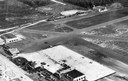
| Date: | 01 1934 |
|---|---|
| Description: | An aerial view of the Oshkosh Airport about three years after Steve Wittman became the manager. The field was established in 1928 by Oshkosh Airport, Inc.... |
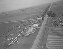
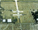
| Date: | 1954 |
|---|---|
| Description: | An aerial view of the air show at Tri-County Airport to celebrate the re-opening of the field under local management. Because of its location at the inters... |
| Date: | |
|---|---|
| Description: | An aerial view of the Milwaukee County Airport. The office, also seen in Image ID: 11454 is visible in the lower left corner. |
| Date: | |
|---|---|
| Description: | The airfield of the Hamilton Aero Manufacturing Company which became the site of Milwaukee County Airport in 1926. It was established by Thomas Hamilton, a... |
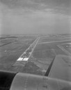
| Date: | 1954 |
|---|---|
| Description: | Aerial view of a new landing strip at Truax Field as photographed from a low-flying airplane. |

| Date: | 06 1962 |
|---|---|
| Description: | Distant view of U.S helicopters over the Delta Region of South Vietnam taken by Dickey Chapelle, a freelance photographer from Milwaukee. |

| Date: | 11 16 2001 |
|---|---|
| Description: | Aerial view of General Mitchell International in Milwaukee, looking southeast to the Lake Michigan shoreline. |

| Date: | 1942 |
|---|---|
| Description: | Aerial view of Oscar Mayer & Company, 910 Mayer Avenue at Packers Avenue. Shows stock yards, railroad cars and automobile parking lot. Also shows C.E. & P.... |
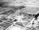
| Date: | 12 14 1931 |
|---|---|
| Description: | Aerial view of Madison industrial district taken from the top of the Madison Gas and Electric Co. gas tank looking south west down the 600 and 700 blocks o... |
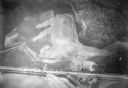
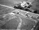
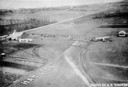
| Date: | 04 09 1931 |
|---|---|
| Description: | Aerial view of Lake Delton airport. |

| Date: | 1945 |
|---|---|
| Description: | View of the lower campus of the University of Wisconsin-Madison includes Bascom Hill, Wisconsin Historical Society, Memorial Union and the Armory (Red Gym ... |

| Date: | 1945 |
|---|---|
| Description: | Aerial view of Bascom Hill, Bascom Hall, Wisconsin Historical Society on the University of Wisconsin Madison campus with Lake Mendota on the right. |
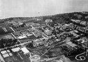
| Date: | 1923 |
|---|---|
| Description: | Aerial view of the University of Wisconsin campus shows from west to east the Agricultural Hall, Observatory Hall and the Wisconsin Historical Society with... |

| Date: | 1926 |
|---|---|
| Description: | Originally titled 'Recent Aeroplane View of University Campus', the view of the Wisconsin Historical Society, the Red Gym, Science Hall and Bascom Hall wit... |

| Date: | 1923 |
|---|---|
| Description: | Aerial view of the Wisconsin Historical Society, Science Hall, and Bascom Hall on Bascom Hill on the University of Wisconsin-Madison campus. Lake Mendota i... |
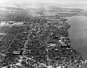
| Date: | 1946 |
|---|---|
| Description: | Aerial view of the University of Wisconsin campus with Lake Mendota on the right. |
If you didn't find the material you searched for, our Library Reference Staff can help.
Call our reference desk at 608-264-6535 or email us at: