Filter: Categories of Wisconsin Historical Images
Filter: Subject of Aerial photographs
Filter: Subject of sidewalks
Filter: Categories of Wisconsin Historical Images
Filter: Subject of Aerial photographs
Filter: Subject of sidewalks

| Date: | 1928 |
|---|---|
| Description: | Aerial view of the Wisconsin State Capitol, looking northeast. The Park Hotel on the corner of W. Main Street and S. Carroll Street, is in the foreground. |
| Date: | |
|---|---|
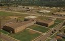
| Description: | Aerial view of the high school, 2100 Fenwick Avenue, and the surrounding roads. |

| Date: | 1957 |
|---|---|
| Description: | Aerial view of the north corner of Capitol Square looking toward Lake Mendota. The Belmont Hotel is featured prominently. |

| Date: | 05 05 1947 |
|---|---|
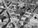
| Description: | Aerial view of the intersection of Pinckney, Main, and King Streets on the Madison Capitol Square. Kresge's, 27 East Main Street, can be seen at the upper ... |

| Date: | 05 05 1947 |
|---|---|
| Description: | Aerial view of Main, King, and Pinckney Streets intersection on Madison's Capitol Square. View is looking south down Pinckney Street. Kresge's, 27 East Mai... |

| Date: | 09 1996 |
|---|---|
| Description: | "Theresa's Bonduel & Wisconsin Streets from the air." |

| Date: | 1954 |
|---|---|
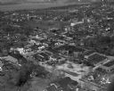
| Description: | Aerial view of the west side of Madison showing newly constructed homes and homes under construction featured in the Parade of Homes. The main road through... |

| Date: | |
|---|---|
| Description: | Aerial view of the Capitol Square, with Capitol Park and part of the Wisconsin State Capitol. Manchester's is on the corner of Mifflin Street at Wisconsin ... |
| Date: | |
|---|---|
| Description: | Aerial view of Madison, including Yost's, State Street, The Orpheum Theatre, Hills, the Madison Public Library, block 64 parking, East Johnson Street, and ... |

| Date: | 1950 |
|---|---|
| Description: | Aerial view of the Wisconsin State Capitol and Square. |

| Date: | |
|---|---|
| Description: | Aerial view of Capitol Square from above King Street. Caption reads: "Aeroplane View of State Capitol, Madison, Wis." Text on reverse reads: "Constructi... |
| Date: | 1920 |
|---|---|
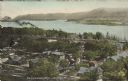
| Description: | Text on front reads: "Trempealeau, Wis., on-the-Mississippi." Aerial view of the town on the Mississippi River. |
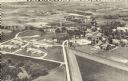
| Date: | 1921 |
|---|---|
| Description: | Text on reverse reads: "Southern Wisconsin Colony and Training School. Union Grove, Wis." Aerial view of a large facility. Opened in 1919 as the "Southern ... |

| Date: | 1985 |
|---|---|
| Description: | Text on reverse reads: "Aerial View. Winnebago State Hospital. Winnebago, Wis. Administration building, all Faith Chapel, Gordon hall, North Cottage and th... |
If you didn't find the material you searched for, our Library Reference Staff can help.
Call our reference desk at 608-264-6535 or email us at: