 Filter: Categories of Wisconsin Historical Images
Filter: FULL_DATE of 1965
Filter: Subject of transportation
Filter: Type of Map or Atlas
Filter: Categories of Wisconsin Historical Images
Filter: FULL_DATE of 1965
Filter: Subject of transportation
Filter: Type of Map or Atlas
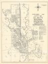
| Date: | 1965 |
|---|---|
| Description: | Shows city limits, plat of town, local streets, railroads, and Baraboo River. "Revised by Mid-State Associates, Baraboo, Wisconsin, April 6, 1965" Upper ri... |

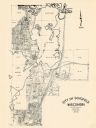
| Date: | 1965 |
|---|---|
| Description: | Map shows original plat, plat additions, and lot measurements for Rothschild, Wisconsin. Lake Wausau and the Wisconsin River are labelled. Map reads: "Comp... |
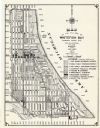
| Date: | 1965 |
|---|---|
| Description: | This map shows Milwaukee County Parkway lands, streets, streets not yet constructed, public facilities, schools, churches, and manufacturers. The map inclu... |
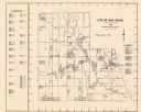
| Date: | 1965 |
|---|---|
| Description: | This map shows lot and block numbers and dimensions, additions, streets, and railroads. |

| Date: | 1965 |
|---|---|
| Description: | This map shows lot and block numbers and dimensions, railroads, and streets and is dated: "March 1965." The map includes manuscript annotations that show m... |

| Date: | 1965 |
|---|---|
| Description: | This basic street map shows roads, schools, parks and cemeteries and includes a street index in the lower margin. The map also shows a portion of Elm Grove... |

| Date: | 1965 |
|---|---|
| Description: | This map shows proposed streets, arterial and collector streets, lot numbers and dimensions, parks, the disposal plant, a ball park, and school property. T... |

| Date: | 1965 |
|---|---|
| Description: | This map shows wards, city limits, railroad right of way, proposed future streets, and approximate street elevations. Wards and public schools are labeled ... |

| Date: | 1965 |
|---|---|
| Description: | This map is indexed for public buildings and includes a numbered key on the lower left side. The streets are labeled and Lake Michigan is labeled on the fa... |

| Date: | 1965 |
|---|---|
| Description: | This map shows streets, churches, schools, wards, railroads, parks and fields, cemeteries, Historical Museum, Yacht Basin & Marina, and Marinette General H... |

| Date: | 1965 |
|---|---|
| Description: | This map shows wards, schools and public buildings, and polling places. The map includes a street index. Lac La Belle, Fowler Lake, and Oconomowoc Lake are... |
| Date: | 1965 |
|---|---|
| Description: | This map shows 8 zoning districts, as well as house number system, schools, parks, churches, and points of interest. Lake Michigan is labeled and the lower... |

| Date: | 1965 |
|---|---|
| Description: | This map shows landownership, acreages, and roads. The city of De Pere, the town of Hobart, and the Fox River are labeled. Inset maps showing Smits Subdivi... |
| Date: | 1965 |
|---|---|
| Description: | This map covers the vicinity of Arbor Vitae, Woodruff, and Minocqua: east to Mishonagon Creek, west to Gilmore Lake, north to Lower Gresham Lake, and south... |

| Date: | 1965 |
|---|---|
| Description: | This series of 17 maps show boundaries and changes in city limits from 1846 to 1965. The base of all of the maps are the same, Milwaukee and suburbs. All m... |

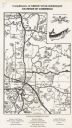
| Date: | 1965 |
|---|---|
| Description: | This colored road map shows automobile roads in Wisconsin as well as portions of nearby states. Information on the quality and type of any road shown (inte... |
If you didn't find the material you searched for, our Library Reference Staff can help.
Call our reference desk at 608-264-6535 or email us at: