Filter: Categories of Wisconsin Historical Images
Filter: FULL_DATE of 1960
Filter: Subject of roads
Filter: Subject of cities and towns
Filter: Categories of Wisconsin Historical Images
Filter: FULL_DATE of 1960
Filter: Subject of roads
Filter: Subject of cities and towns
| Date: | 1960 |
|---|---|
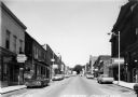
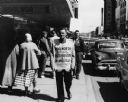
| Description: | View of businesses on High Street, including the Rexall Drugstore on the left corner. One can also see a glimpse of the City Hall, directly across the stre... |
| Date: | 1960 |
|---|---|
| Description: | Group of protesters march in front of a Howard Johnson's restaurant holding signs. One says "Segregation OUT!! Integration IN!! CORE - NAACP". |

| Date: | 1960 |
|---|---|
| Description: | View across road towards the Mosinee Paper Company. |

| Date: | 1960 |
|---|---|
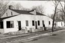
| Description: | View from street of house numbers 2813-2817 Center Avenue. Two cars parked on the road are covered in snow. |

| Date: | 1960 |
|---|---|
| Description: | View from street of houses on the south side of Madison. The cars parked in front of the house are covered in snow. |
| Date: | 1960 |
|---|---|
| Description: | Women's dormitory on the University of Wisconsin-Madison campus at the corner of Park Street and University Avenue. |
| Date: | 1960 |
|---|---|
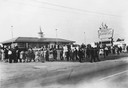
| Description: | Members of a Des Moines United Packinghouse Workers of America local picket outside a Woolworth's store to demonstrate their opposition to segregation of W... |

| Date: | 1960 |
|---|---|
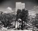
| Description: | Aerial view of the Dane County Hospital, looking west. Excavating for a more modern east wing that was finished in 1960 can be seen near the main building.... |

| Date: | 1960 |
|---|---|
| Description: | Aerial view of the Dane County Hospital, looking north. Excavating for a more modern east wing that was finished in 1960 can be seen. It had been called t... |
| Date: | 1960 |
|---|---|
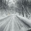
| Description: | A winter scene down a road in the snow-covered arboretum. |

| Date: | 1960 |
|---|---|
| Description: | This mid-20th century tourist brochure for Bayfield County, Wisconsin, includes a map of the county showing towns, cities and villages, highways and roads,... |

| Date: | 1960 |
|---|---|
| Description: | Color coded map in pink, yellow, blue, and brown of Milwaukee County State and County trunk highways. The map includes a legend of symbols: "STEAM RAIL ROA... |

| Date: | 1960 |
|---|---|
| Description: | This map shows a plat of the city, wards, lots, local streets, roads, railroads, buildings, parks, and part of Fox River. The map includes tables for plat ... |

| Date: | 1960 |
|---|---|
| Description: | This map shows public boat ramps, parks, highways, beaches, bluffs, Green Bay, Garrett Bay, Europe Bay and Lake, Rowley's Bay and Ellison Bay. The map incl... |

| Date: | 1960 |
|---|---|
| Description: | This pictorial map shows recreation activities, rivers, lakes, and the history of the area. The map covers Langlade County and parts of adjacent counties. ... |

| Date: | 1960 |
|---|---|
| Description: | This map shows improved town roads, federal highways, county highways, public boat access, public hunting areas, railroads, and lakes in the area around th... |

| Date: | 1960 |
|---|---|
| Description: | This map shows U.S. highways, state highways, county highways, town roads, county parks, county highway buildings, waysides, rivers, lakes, airports, a civ... |

| Date: | 1960 |
|---|---|
| Description: | This colored road map shows roads in Wisconsin as well as portions of nearby states. Information on the quality and type of any road shown can be found in ... |
If you didn't find the material you searched for, our Library Reference Staff can help.
Call our reference desk at 608-264-6535 or email us at: