 Filter: Categories of Wisconsin Historical Images
Filter: FULL_DATE of 1960
Filter: County of Dane
Filter: Subject of cities and towns
Filter: Subject of architecture
Filter: Categories of Wisconsin Historical Images
Filter: FULL_DATE of 1960
Filter: County of Dane
Filter: Subject of cities and towns
Filter: Subject of architecture
| Date: | 1960 |
|---|---|
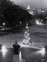
| Description: | Elevated view looking east from Lincoln Terrace on Bascom Hill on the University of Wisconsin-Madison campus. The Lincoln Monument is in the foreground and... |
| Date: | 1960 |
|---|---|
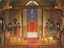
| Description: | Elevated view of the interior of the front area in Bethel Lutheran Church, showing the altar and large stained glass window. |
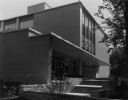
| Date: | 1960 |
|---|---|
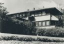
| Description: | A view from the east of the Gilmore-Weiss House, 120 Ely Place, designed by Frank Lloyd Wright. |
| Date: | 1960 |
|---|---|
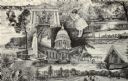
| Description: | Views of popular sites in Madison. Numerous different types of recreation are depicted, along with popular sites such as the Wisconsin State Capitol buildi... |

| Date: | 1960 |
|---|---|
| Description: | Exterior of square brick building, on a hill with a retaining wall and steps leading up to the front entrance. Designed by John J. Flad & Associates (Archi... |

| Date: | 1960 |
|---|---|
| Description: | Exterior view of the Town of Madison town hall building located at 2120 Fish Hatchery Road. |

| Date: | 1960 |
|---|---|
| Description: | Exterior of Field House on the University of Wisconsin-Madison campus. Many of the University's indoor sports events were held here. Camp Randall stadium i... |
| Date: | 1960 |
|---|---|
| Description: | Women's dormitory on the University of Wisconsin-Madison campus at the corner of Park Street and University Avenue. |
| Date: | 1960 |
|---|---|
| Description: | Exterior view of the front of the Wisconsin Center, 702 Langdon Street, including the stairs. |

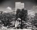
| Date: | 1960 |
|---|---|
| Description: | Aerial view of the Dane County Hospital, looking west. Excavating for a more modern east wing that was finished in 1960 can be seen near the main building.... |

| Date: | 1960 |
|---|---|
| Description: | Aerial view of the Dane County Hospital, looking north. Excavating for a more modern east wing that was finished in 1960 can be seen. It had been called t... |

| Date: | 1960 |
|---|---|
| Description: | This map shows block numbers, tract numbers, tract boundaries, city limits, local streets, railroads, Lake Mendota, and Lake Monona. |

| Date: | 1960 |
|---|---|
| Description: | The State Historical Society of Wisconsin building and grounds after a snowstorm. State Street is on the far left, with Bascom Hill in the background. |
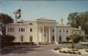
| Date: | 1960 |
|---|---|
| Description: | Exterior view from driveway of the Governor's Mansion in Maple Bluff. Flags are flying from a flagpole in the yard on the left. Columns frame the front ent... |
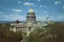
| Date: | 1960 |
|---|---|
| Description: | Elevated view of the Capitol's West Washington entrance. Lake Monona is on the right, and Lake Mendota is on the left. |

| Date: | 1960 |
|---|---|
| Description: | Text on front reads: "Historical Museum, Erected as the First Church in 1858. Stoughton, Wisconsin." Handwritten on reverse: "Look this [??]t history of St... |

| Date: | 1960 |
|---|---|
| Description: | Exterior front view from left of Tony Urso's Westside Palm Tavern located at 730-736 West Washington Avenue in the Greenbush neighborhood. There are two bi... |
If you didn't find the material you searched for, our Library Reference Staff can help.
Call our reference desk at 608-264-6535 or email us at:
