 Filter: Categories of Wisconsin Historical Images
Filter: FULL_DATE of 1954
Filter: Subject of human settlements
Filter: Categories of Wisconsin Historical Images
Filter: FULL_DATE of 1954
Filter: Subject of human settlements

| Date: | 1954 |
|---|---|
| Description: | View from atop a building across Wisconsin Avenue of the Fuller Opera House during its demolition. |
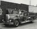
| Date: | 1954 |
|---|---|
| Description: | International fire truck used by the Granite City Fire Department. Original caption reads: 'R-1856 - 175" wheelbase. RD450 engine. 9.00x20-10 ply tires. 30... |

| Date: | 1954 |
|---|---|
| Description: | John Berry holds a baby as he poses with his wife Pearl. |
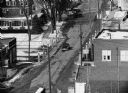
| Date: | 1954 |
|---|---|
| Description: | "Telephoto picture of the old bridge. Note Highway is 175." |
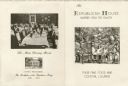
| Date: | 1954 |
|---|---|
| Description: | Back and front of a small folded card menu, with an etching of a quarter view of the exterior of Republican House surrounded by leafy trees on the front co... |

| Date: | 1954 |
|---|---|
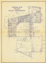
| Description: | This map of Waukesha shows numbered ward boundaries, roads, and some buildings. The bottom of the map includes a street index. |
| Date: | 1954 |
|---|---|
| Description: | This map of Wausau is pink, red, gray, and white. The map includes indexes of streets, industries, and community buildings and features a photograph of the... |

| Date: | 1954 |
|---|---|
| Description: | This map of La Crosse shows residential, multiple dwelling, local business, commercial, light industrial, heavy industrial and special multiple dwelling la... |

| Date: | 1954 |
|---|---|
| Description: | Aerial view of the west side of Madison showing newly constructed homes and homes under construction featured in the Parade of Homes. The main road through... |
| Date: | 1954 |
|---|---|
| Description: | This blue line print shows lot and block numbers and dimensions, additions, railroads, streets, and parks. |

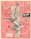
| Date: | 1954 |
|---|---|
| Description: | This map shows the location of Catholic churches, missions, and shrines. The map is color coded and includes a key in the bottom left corner. The back of t... |

| Date: | 1954 |
|---|---|
| Description: | Elevated view from the Wisconsin State Capitol looking west up State Street toward the University of Wisconsin. Frozen Lake Monona is on the right. |
| Date: | 1954 |
|---|---|
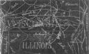
| Description: | This photocopy map shows a early sketch of the settlement Southport. Rivers, lakes, other settlements, county boundaries, and roads are labeled. A portion ... |
| Date: | 1954 |
|---|---|
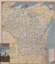
| Description: | This map is designed to help Catholic tourists in Wisconsin find Catholic churches and missions. On the front side, a road map of Wisconsin showing the loc... |

| Date: | 1954 |
|---|---|
| Description: | Kodachrome postcard of the grounds and buildings of the Honey Bear Farm. A group of women walking along a pathway lined with flowers. Text on reverse reads... |
| Date: | 1954 |
|---|---|
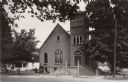
| Description: | View across street towards the church. The entrance and steeple are on the right. Caption reads: "First Congregational Church, Hillsboro, Wis." |
| Date: | 1954 |
|---|---|
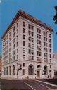
| Description: | The First National Bank building on the corner of South Pinckney Street and East Washington Avenue. |
| Date: | 1954 |
|---|---|
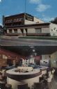
| Description: | Two views of a restaurant, outdoor view, and indoor view of the bar area. Located at 613-617 W. Main Street. |

| Date: | 1954 |
|---|---|
| Description: | Night view of the front entrance of the University of Wisconsin YMCA at 306 North Brooks Street. |
| Date: | 1954 |
|---|---|
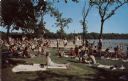
| Description: | Color postcard view of a crowded bathing beach at Lake Wingra. |
If you didn't find the material you searched for, our Library Reference Staff can help.
Call our reference desk at 608-264-6535 or email us at: