Filter: Categories of Wisconsin Historical Images
Filter: FULL_DATE of 1939
Filter: Subject of land use
Filter: Categories of Wisconsin Historical Images
Filter: FULL_DATE of 1939
Filter: Subject of land use
| Date: | 1939 |
|---|---|
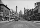
| Description: | A view from the 200 block of State Street looking toward the Wisconsin State Capitol. This urban scene includes marquees for the Orpheum Theatre and the Ca... |
| Date: | 1939 |
|---|---|
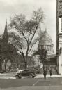
| Description: | View down sidewalk along West Washington Avenue, looking toward the Capitol. A man is crossing the street and there is a car at the corner that has the wor... |
| Date: | 1939 |
|---|---|
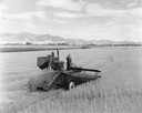
| Description: | Elevated view of men harvesting grain with a McCormick-Deering 12 foot experimental combine (harvester-thresher) pulled by a Farmall M tractor. There is a ... |
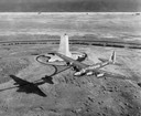
| Date: | 1939 |
|---|---|
| Description: | Aerial view of a B-15 flying over the granite memorial to the Wright Brothers' first flight at Kitty Hawk, North Carolina. The 60-foot memorial was dedicat... |
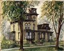
| Date: | 1939 |
|---|---|
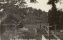
| Description: | The Simeon Mills house, located at 222 Monona Avenue. |
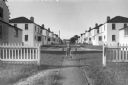
| Date: | 1939 |
|---|---|
| Description: | A child peddles his tricycle on a sidewalk at the end of a cul de sac in his Greendale neighborhood with houses lining the street. |
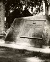
| Date: | 1939 |
|---|---|
| Description: | The Timothy Burns tablet in Burns Park, near Main Street. The tablet reads: "To perpetuate the record of the gift of Burns Park to La Crosse by Hon. Timoth... |
| Date: | 1939 |
|---|---|
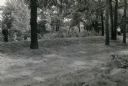
| Description: | Burl Briggs (far left), and unknown companions pose near a linear burial mound on Picnic Point on the University of Wisconsin-Madison campus. |
| Date: | 1939 |
|---|---|
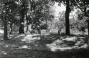
| Description: | Burl Briggs (right), and an unknown companion pose behind a linear burial mound on the University of Wisconsin-Madison campus. |
| Date: | 1939 |
|---|---|
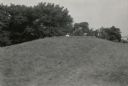
| Description: | A man poses behind a large conical Native American burial mound near the center of Picnic Point on the University of Wisconsin-Madison campus. |

| Date: | 1939 |
|---|---|
| Description: | A man poses behind a conical Native American burial mound near the west end of Picnic Point on the University of Wisconsin-Madison campus. |
| Date: | 1939 |
|---|---|
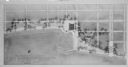
| Description: | The proposed Mendota Lake Front Development Plan, William Kaeser, architect. |

| Date: | 1939 |
|---|---|
| Description: | A color, pictorial map. Scale: 10 miles to the inch. Shows state parks and forests, proposed state parkways, proposed state monuments and memorials, nation... |
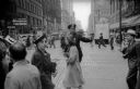
| Date: | 1939 |
|---|---|
| Description: | A Chicago police officer holds up his hand to signal pedestrians that they should not enter the crosswalk. |
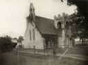
| Date: | 1939 |
|---|---|
| Description: | St. Mary's in the Field, an Episcopal church "located at the northwest corner of the intersection of highways 67 and 18. It is just east of the former Van ... |
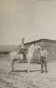
| Date: | 1939 |
|---|---|
| Description: | Gaylord Nelson, later Wisconsin governor, United State senator, and a leading environmentalist of his era, on horseback at a ranch in Rosebud, Montana. |

| Date: | 1939 |
|---|---|
| Description: | Shocks of wheat lined up in a large field. There is a mountain range in the background. |

| Date: | 1939 |
|---|---|
| Description: | A group of pedestrians crossing the street outside of Liggetts Drugstore, located in the Tenney Building on Capitol Square. |
If you didn't find the material you searched for, our Library Reference Staff can help.
Call our reference desk at 608-264-6535 or email us at: