 Filter: Categories of Wisconsin Historical Images
Filter: FULL_DATE of 1931
Filter: Subject of rivers
Filter: Categories of Wisconsin Historical Images
Filter: FULL_DATE of 1931
Filter: Subject of rivers
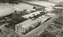
| Date: | 1931 |
|---|---|
| Description: | Aerial view of International Harvester's Rock Falls Works. The factory was owned by the Keystone Manufacturing Company until 1904, when the company was pur... |

| Date: | 1931 |
|---|---|
| Description: | Aerial view looking north, with a small portion of the West Side (left), nearly all of the North Side and part of the business district of the East Side. A... |

| Date: | 1931 |
|---|---|
| Description: | Second to last steamboat on the river taken before 1931, burned in 1931. Taken from Romance Cliff, "The Apollo" is shown coming through with smoke billowin... |

| Date: | 1931 |
|---|---|
| Description: | A map of the village of Verona, Wisconsin. |

| Date: | 1931 |
|---|---|
| Description: | International poster featuring testimony from the builders of the Hoover Dam in their use of International trucks. The poster has two photographs of trucks... |

| Date: | 1931 |
|---|---|
| Description: | Elevated view looking down through Black Canyon to the Colorado River, the future site of the Hoover Dam. |

| Date: | 1931 |
|---|---|
| Description: | Elevated view looking down through Black Canyon to the Colorado River, the future site of the Hoover Dam. |
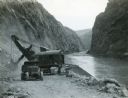
| Date: | 1931 |
|---|---|
| Description: | An International truck waits to be loaded with boulders blasted from the walls of Black Canyon during the construction of the Hoover Dam. The Colorado Rive... |
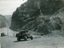
| Date: | 1931 |
|---|---|
| Description: | Men drive an International truck up a dirt road along the Colorado River during the construction of the Hoover Dam in Black Canyon. There is a steam, or po... |
| Date: | 1931 |
|---|---|
| Description: | This map "sets out the more important points of historic interest designated by the National Society of Colonial Dames in Wisconsin" and includes illustrat... |

| Date: | 1931 |
|---|---|
| Description: | This U.S. Geological Survey map of Wisconsin shows counties, cities and villages, lighthouses, Indian reservations, military reservations, and bird and gam... |

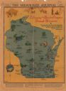
| Date: | 1931 |
|---|---|
| Description: | This map of south central Wisconsin shows lakes, rivers, cities, villages, highways and roads, railroads, Indian mounds, and points of scenic and historic ... |

| Date: | 1931 |
|---|---|
| Description: | Page from an advertising brochure for International trucks. International trucks are used during the construction of an inter-county bridge between Columbi... |

| Date: | 1931 |
|---|---|
| Description: | A topographical map from the U.S. Army Corp of Engineers showing the topography and man-made features in the Camp Williams area of the towns of Orange and ... |
| Date: | 1931 |
|---|---|
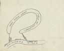
| Description: | Prepared by Robert K. Boyd for his article "Up and down the Chippewa River" which appeared in the March 1931 issue of the Wisconsin Magazine of History, th... |
| Date: | 1931 |
|---|---|
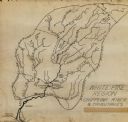
| Description: | This manuscript map shows the Chippewa River watershed, including the Red Cedar or Menomonie River, Flambeau or Manitowish River, Jump River, Eau Claire Ri... |

| Date: | 1931 |
|---|---|
| Description: | This map is an advertisement for Milwaukee street cars and motor buses and reads: "Ride the street car or motor bus. Economical, safe, dependable." Include... |

| Date: | 1931 |
|---|---|
| Description: | Relief shown by contours and spot heights. Maps shows United States, state, county and local highways and roads, schools, North Bend, creeks, lakes, rivers... |

| Date: | 1931 |
|---|---|
| Description: | Map shows street map with wards numbered, the Fox River, railroads, playgrounds, cemeteries, and schools. The map also includes a manuscript annotation ind... |
| Date: | 1931 |
|---|---|
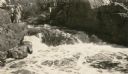
| Description: | A group of people stand on a ledge overlooking Copper Falls. |
If you didn't find the material you searched for, our Library Reference Staff can help.
Call our reference desk at 608-264-6535 or email us at: