 Filter: Categories of Wisconsin Historical Images
Filter: FULL_DATE of 1911
Filter: Categories of Wisconsin Historical Images
Filter: FULL_DATE of 1911

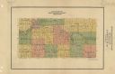
| Date: | 1911 |
|---|---|
| Description: | A map of the Racine, Kenosha, and portions of Milwaukee counties, that shows the townships in Racine and Kenosha, and the townships of Brookfield, New Berl... |

| Date: | 1911 |
|---|---|
| Description: | Rear view of the sternwheel paddle boat 'Dubuque of ?" on the Mississippi River near Cassville, Wisconsin. This postcard is marked 'Souvenir' by Frank Feik... |

| Date: | 1911 |
|---|---|
| Description: | This map of Polk County, Wisconsin, from the early 20th century shows the land for sale by the Baker Land and Title Co. of Saint Croix Falls. The township ... |

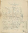
| Date: | 1911 |
|---|---|
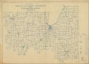
| Description: | This 1911 map shows the Post Office's rural routes in Racine County, Wisconsin, and portions of eastern Walworth and northern Kenosha counties. The locatio... |

| Date: | 1911 |
|---|---|
| Description: | This 1911 map of south central Sawyer County, Wisconsin, shows land for sale by Veness & Kasl of Exeland, the township and range system, sections, homes, r... |
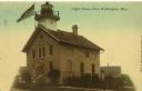
| Date: | 1911 |
|---|---|
| Description: | Tinted postcard view of the lighthouse at Port Washington. A U.S. flag flies above the roof at the upper left. Caption reads: "Light House, Port Washington... |

| Date: | 1911 |
|---|---|
| Description: | This map, taken from the 1911 Map of Wisconsin showing geology and roads by Hotchkiss and Thwaites, shows the northwest portion of Douglas County, Wisconsi... |

| Date: | 1911 |
|---|---|
| Description: | This 1911 map of the geology of northern Wisconsin between Superior and Hurley was published by the Wisconsin Geological and Natural History Survey in Fred... |
| Date: | 1911 |
|---|---|
| Description: | Map shows townships and sections, roads, and railroads. "W.W. Downs, attorney-at-law, Eau Claire, Wis." |

| Date: | 1911 |
|---|---|
| Description: | This 1911 map from the U.S. Post Office Dept. shows rural delivery routes, active and discontinued post offices, selected rural landowners and houses, chur... |

| Date: | 1911 |
|---|---|
| Description: | This 1911 map from the U.S. Post Office Dept. shows rural delivery routes, active and discontinued post offices, collection boxes, selected rural landowner... |

| Date: | 1911 |
|---|---|
| Description: | Blue line print. Shows post offices, houses, schools, churches, roads, routes, rivers, and railroads. Includes explanation of symbols. "H.G.M. October 12,... |
| Date: | 1911 |
|---|---|
| Description: | Shows routes, post offices, churches, houses, schools, roads, and collection boxes. "B. Oct. 11, 1911." Blue line print. "Sheboygan Co., Wis. 587." |

| Date: | 1911 |
|---|---|
| Description: | Shows roads, railroads, street railways, abandoned logging railroads, rural mail routes, platted land, state forest reserves, and parts of Burnett County, ... |

| Date: | 1911 |
|---|---|
| Description: | This 1911 map from the U.S. Post Office Department shows rural delivery routes, active and discontinued post offices, selected rural landowners and houses,... |
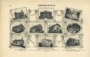
| Date: | 1911 |
|---|---|
| Description: | "Standard Historical Atlas of Dane County, Wisconsin." Top half of page 98, showing all of the different district schools in Middleton. |
| Date: | 1911 |
|---|---|
| Description: | Shows roads, railroads, post offices, schools, houses, churches, routes, and collection boxes. Includes distant chart and explanation. "Price 35 cents"--... |

| Date: | 1911 |
|---|---|
| Description: | This hand-colored map is a 1911 copy of a map drawn by Gaspard-Joseph Chaussegros de Léry in 1730 showing the Fox River from its mouth at Green Bay to Lake... |

| Date: | 1911 |
|---|---|
| Description: | Shows roads, railroads, post offices, schools, houses, churches, and routes. Includes distant chart and explanation. "Price 35 cents"--Upper left margin. "... |

| Date: | 1911 |
|---|---|
| Description: | A view looking up King Street from Butler Street toward the Wisconsin State Capitol. It appears there is work being done on the dome. |
If you didn't find the material you searched for, our Library Reference Staff can help.
Call our reference desk at 608-264-6535 or email us at: