Filter: Categories of Wisconsin Historical Images
Filter: FULL_DATE of 1911
Filter: Subject of indians of north america
Filter: Categories of Wisconsin Historical Images
Filter: FULL_DATE of 1911
Filter: Subject of indians of north america
| Date: | 1911 |
|---|---|
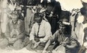
| Description: | Indians playing a game at Lac du Flambeau, Wisconsin. "The man in the center is holding counting sticks. A constant drumming is kept up to make concentra... |
| Date: | 1911 |
|---|---|
| Description: | Joe Wisconsin, a Potowatomi Indian, grandson of Sheboygan war chief Pa-mob-a-mee. Wisconsin was born at Sheboygan Falls about 1833 and is known to have be... |
| Date: | 1911 |
|---|---|
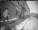
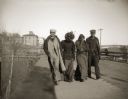
| Description: | A boy is standing on a snow-covered wooden sidewalk on the left, and Native American women wrapped in blankets are walking on the sidewalk on the right. Vi... |
| Date: | 1911 |
|---|---|
| Description: | Four Ho-Chunk people crossing a bridge spanning the Black River. This photograph was taken before the flood of October 1911, when the bridge was completely... |
| Date: | 1911 |
|---|---|
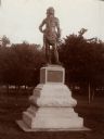
| Description: | A statue of Oshkosh, head chief of the Menominee Indian Tribe in North Park (Menominee Park). Sculpted by Gaetano Trentanove of Florence, Italy. Unveiled J... |
| Date: | 1911 |
|---|---|
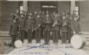
| Description: | Group portrait of the Tomah Indian School Band in uniform, holding their instruments. |
| Date: | 1911 |
|---|---|
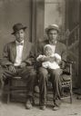
| Description: | Studio portrait in front of a painted backdrop of two Ho-Chunk men posing sitting and wearing suits, bow ties, and hats. Andrew John (Big) Blackhawk (WaCon... |

| Date: | 1911 |
|---|---|
| Description: | This 1911 map of the geology of northern Wisconsin between Superior and Hurley was published by the Wisconsin Geological and Natural History Survey in Fred... |

| Date: | 1911 |
|---|---|
| Description: | This hand-colored map is a 1911 copy of a map drawn by Gaspard-Joseph Chaussegros de Léry in 1730 showing the Fox River from its mouth at Green Bay to Lake... |

| Date: | 1911 |
|---|---|
| Description: | This map shows swamps, railroads, rivers, roads, the Catholic Mission Reserve, the day school, and the Agency Reserve. Lake Superior is labeled. An inset m... |

| Date: | 1911 |
|---|---|
| Description: | This map shows lakes, rivers, swamps, state swamp land, trails and railroads. Includes a township diagram. |

| Date: | 1911 |
|---|---|
| Description: | This map shows railroads, roads, swamps, a school site and farm, and a mill site. The map includes a "typical township" diagram. Lac du Flambeau, Long Lake... |
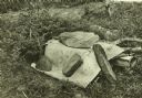
| Date: | 1911 |
|---|---|
| Description: | A birch bark Indian cache weighted down with stones. There is rolled birch bark protruding from beneath it. |

| Date: | 1911 |
|---|---|
| Description: | Display of mostly wooden Indian artifacts, which were seen near Quetico Lake. |

| Date: | 1911 |
|---|---|
| Description: | A dilapidated grave near Mac Laren's Hudson's Bay Company Store and Sturgeon Lake. The coffin is covered with birch bark. |

| Date: | 1911 |
|---|---|
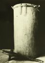
| Description: | A forgotten Indian cache in poor condition assembled by a Medicine Man. The contents include a green skull cap with a fur band, a tool for scraping hair fr... |

| Date: | 1911 |
|---|---|
| Description: | Two graves built side by side within a birch branch enclosure. Each grave has an individual wooden fence around it. |

| Date: | 1911 |
|---|---|
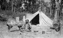
| Description: | Carl standing and looking through the entrance of a tipi (teepee) near Rainy Lake. |

| Date: | 1911 |
|---|---|
| Description: | "Old Bill," a Native American, is carrying a basket or box outdoors in Kettle Falls. There is a large wooden building behind him. |
If you didn't find the material you searched for, our Library Reference Staff can help.
Call our reference desk at 608-264-6535 or email us at: