 Filter: Categories of Wisconsin Historical Images
Filter: FULL_DATE of 1911
Filter: Type of Map or Atlas
Filter: Subject of water
Filter: Categories of Wisconsin Historical Images
Filter: FULL_DATE of 1911
Filter: Type of Map or Atlas
Filter: Subject of water

| Date: | 1911 |
|---|---|
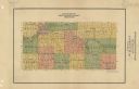
| Description: | Plat Map of Blooming Grove in "Atlas of Dane County, Wisconsin." |

| Date: | 1911 |
|---|---|
| Description: | Map of the west part of the city of Madison. |

| Date: | 1911 |
|---|---|
| Description: | A map of the village of Black Earth and Verona. |

| Date: | 1911 |
|---|---|
| Description: | A business atlas map of Wisconsin, showing the railroads, counties, cities, villages, rivers, lakes, electric lines, and steamship lines in the state. Othe... |

| Date: | 1911 |
|---|---|
| Description: | This map of Wisconsin, the western portion of Michigan's Upper Peninsula, and northern Illinois shows counties, towns, cities and villages, rivers and lake... |

| Date: | 1911 |
|---|---|
| Description: | A map of the Racine, Kenosha, and portions of Milwaukee counties, that shows the townships in Racine and Kenosha, and the townships of Brookfield, New Berl... |

| Date: | 1911 |
|---|---|
| Description: | This map of Polk County, Wisconsin, from the early 20th century shows the land for sale by the Baker Land and Title Co. of Saint Croix Falls. The township ... |

| Date: | 1911 |
|---|---|
| Description: | This 1911 map of south central Sawyer County, Wisconsin, shows land for sale by Veness & Kasl of Exeland, the township and range system, sections, homes, r... |

| Date: | 1911 |
|---|---|
| Description: | This map, taken from the 1911 Map of Wisconsin showing geology and roads by Hotchkiss and Thwaites, shows the northwest portion of Douglas County, Wisconsi... |

| Date: | 1911 |
|---|---|
| Description: | This 1911 map of the geology of northern Wisconsin between Superior and Hurley was published by the Wisconsin Geological and Natural History Survey in Fred... |
| Date: | 1911 |
|---|---|
| Description: | Map shows townships and sections, roads, and railroads. "W.W. Downs, attorney-at-law, Eau Claire, Wis." |

| Date: | 1911 |
|---|---|
| Description: | This 1911 map from the U.S. Post Office Dept. shows rural delivery routes, active and discontinued post offices, selected rural landowners and houses, chur... |

| Date: | 1911 |
|---|---|
| Description: | This 1911 map from the U.S. Post Office Dept. shows rural delivery routes, active and discontinued post offices, collection boxes, selected rural landowner... |

| Date: | 1911 |
|---|---|
| Description: | Blue line print. Shows post offices, houses, schools, churches, roads, routes, rivers, and railroads. Includes explanation of symbols. "H.G.M. October 12,... |

| Date: | 1911 |
|---|---|
| Description: | This 1911 map from the U.S. Post Office Department shows rural delivery routes, active and discontinued post offices, selected rural landowners and houses,... |

| Date: | 1911 |
|---|---|
| Description: | This hand-colored map is a 1911 copy of a map drawn by Gaspard-Joseph Chaussegros de Léry in 1730 showing the Fox River from its mouth at Green Bay to Lake... |

| Date: | 1911 |
|---|---|
| Description: | Map printed in the Milwaukee Herald, 16th of February, 1912. Includes list of Assembly, State Senate, and Congressional districts in bottom margin. Contain... |

| Date: | 1911 |
|---|---|
| Description: | This map of Duluth and Superior shows street car routes, railroads, ferries, some points of interest, and lighthouses. The bottom left of the map reads: "C... |
If you didn't find the material you searched for, our Library Reference Staff can help.
Call our reference desk at 608-264-6535 or email us at:

