 Filter: Categories of Wisconsin Historical Images
Filter: FULL_DATE of 1898
Filter: Subject of church buildings
Filter: Categories of Wisconsin Historical Images
Filter: FULL_DATE of 1898
Filter: Subject of church buildings

| Date: | 1898 |
|---|---|
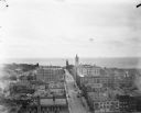
| Description: | Bird's-eye map of Milwaukee with prominent streets and buildings identified. Taken from City Hall Tower. |
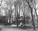
| Date: | 1898 |
|---|---|
| Description: | The replica of the Centennial Fountain in the Capitol Park, where people relax on a park bench. This view looks toward the intersection of Main and Carroll... |
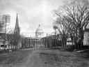
| Date: | 1898 |
|---|---|
| Description: | The third Wisconsin State Capitol as seen from unpaved West Washington Avenue, with the West Wing to the left and the South Wing to the right. The church s... |
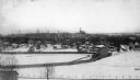
| Date: | 1898 |
|---|---|
| Description: | Camp Randall, with the old stadium in the foreground and the Wisconsin State Capitol in the background. |
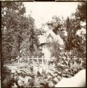
| Date: | 1898 |
|---|---|
| Description: | View of the Chapel of the Woods located at St. Francis Seminary. |

| Date: | 1898 |
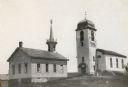
|---|---|
| Description: | Exterior view of the Zwingli Reformed Church. |
| Date: | 1898 |
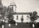
|---|---|
| Description: | Exterior view of Zwingli Reformed Church and cemetery. |
| Date: | 1898 |
|---|---|
| Description: | Exterior view of Zwingli Reformed Church. |
| Date: | 1898 |
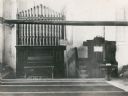
|---|---|
| Description: | Interior view of Zwingli Reformed Church with pulpit and organ. |
| Date: | 1898 |
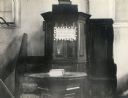
|---|---|
| Description: | Interior view of Zwingli Reformed Church with pulpit. |
| Date: | 1898 |
|---|---|
| Description: | Elevated view from the top of the Pabst Building down East Wisconsin Avenue all the way to Milwaukee Bay and out to the horizon of Lake Michigan. One of th... |

| Date: | 1898 |
|---|---|
| Description: | A map of Iron County, Wisconsin, shows vacant Wisconsin Central Rail Road lands, settlers houses, land sold by Wisconsin Central R.R., schools, churches, s... |

| Date: | 1898 |
|---|---|
| Description: | This 1898 map shows the township and range system, sections, cities and villages, railroads, vacant land, land sold by the Wisconsin Central Railroad, incl... |

| Date: | 1898 |
|---|---|
| Description: | This 1898 map of Sawyer County, Wisconsin, shows the township and range system, sections, roads, farm houses, camps, school houses, dams, bridges, Indian r... |

| Date: | 1898 |
|---|---|
| Description: | This 1898 map shows the township and range system, sections, cities and villages, railroads, roads, vacant land and land sold by the Wisconsin Central Rail... |

| Date: | 1898 |
|---|---|
| Description: | Map showing the contour depths of the lakes in northwestern Waukesha County, Wisconsin. Roads, railroads, depots, churches, schools, and hotels in the area... |
| Date: | 1898 |
|---|---|
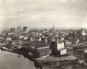
| Description: | Bird's-eye view of Manitowoc taken from Northern Grain Company's Elevator B, facing southeast. South Main (Tenth) Street intersects with Franklin Street in... |
If you didn't find the material you searched for, our Library Reference Staff can help.
Call our reference desk at 608-264-6535 or email us at: