 Filter: Categories of Wisconsin Historical Images
Filter: FULL_DATE of 1891
Filter: Subject of roads
Filter: Categories of Wisconsin Historical Images
Filter: FULL_DATE of 1891
Filter: Subject of roads

| Date: | 1891 |
|---|---|
| Description: | Bird's-eye map of Wausau, looking north with ninety-eight businesses, industries, churches, schools, and civic buildings identified in location key below i... |

| Date: | 1891 |
|---|---|
| Description: | Bird's-eye map of Stevens Point, looking east, with an inset of the Water Works. Wisconsin River in foreground with fifty-three business locations identifi... |

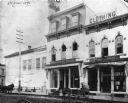
| Date: | 1891 |
|---|---|
| Description: | Woman in a tilted hat posing in the foreground. Across the street are stores: J.J. McGillivray Sash and Door Company and Squire's Oyster House. Probably on... |
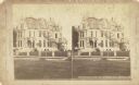
| Date: | 1891 |
|---|---|
| Description: | Stereograph of the home of Charles Ray, 88 Prospect Street. |
| Date: | 1891 |
|---|---|
| Description: | Exterior view of Schuette Brothers Store on S. Eighth Street. There are two horse-drawn vehicles in front of the store. There is a small mannequin in the s... |
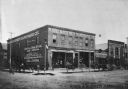
| Date: | 1891 |
|---|---|
| Description: | Exterior view from street of Rand & Roemer Hardware Co. and Henry Hinrich's Drug Store. Also visible are Rand & Roemer Ship Chandlery (nautical supply), Ra... |
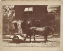
| Date: | 1891 |
|---|---|
| Description: | Julia, the cook, on the rolling machine pulled by a team of horses wearing fly-nets. She is wearing a full-length dress and holding a whip in her right han... |

| Date: | 1891 |
|---|---|
| Description: | A deeply rutted dirt road leads to a bridge over a river. Buildings are on both sides of the river. Bluffs and hills with trees are in the background. This... |

| Date: | 1891 |
|---|---|
| Description: | A hand-colored map of Milwaukee County, Wisconsin that shows the township and range system, sections, towns, roads, railroads and rail stations, cities and... |

| Date: | 1891 |
|---|---|
| Description: | Map of a proposed subdivision. Map reads: "United States Investment Association SUBDIVISION No. 1 In S.W. 1/4 Sec. 33, Town 8, Range 22 East. Is situated a... |

| Date: | 1891 |
|---|---|
| Description: | This map shows railroads, electric street railways, block numbers, docks, roads, parks, light houses, selected buildings, and sites for manufacturers. The ... |

| Date: | 1891 |
|---|---|
| Description: | This map shows vacant Southwick & Sellers lands, settlers' houses, Goodland Co. land, schools, churches, saw mills, roads, and railroads. A key in the uppe... |

| Date: | 1891 |
|---|---|
| Description: | This blueprint manuscript map shows land owned by Green Bay & Mississippi Canal Co., Meade, Vilas, Patten, and Hewitt. Streets and the Fox River are labele... |
If you didn't find the material you searched for, our Library Reference Staff can help.
Call our reference desk at 608-264-6535 or email us at:
