 Filter: Categories of Wisconsin Historical Images
Filter: FULL_DATE of 1891
Filter: Subject of human settlements
Filter: Categories of Wisconsin Historical Images
Filter: FULL_DATE of 1891
Filter: Subject of human settlements
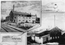
| Date: | 1891 |
|---|---|
| Description: | Composite photograph showing the tanneries of L.M. Sherman and Henry Vits. |
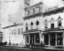
| Date: | 1891 |
|---|---|
| Description: | Exterior view of Schuette Brothers Store on S. Eighth Street. There are two horse-drawn vehicles in front of the store. There is a small mannequin in the s... |
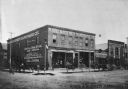
| Date: | 1891 |
|---|---|
| Description: | Exterior view from street of Rand & Roemer Hardware Co. and Henry Hinrich's Drug Store. Also visible are Rand & Roemer Ship Chandlery (nautical supply), Ra... |
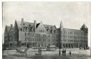
| Date: | 1891 |
|---|---|
| Description: | Exterior view of the West Superior Hotel. There are pedestrians, a street car, and people riding in horse-drawn carriages on the street in front of the hot... |
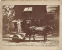
| Date: | 1891 |
|---|---|
| Description: | Julia, the cook, on the rolling machine pulled by a team of horses wearing fly-nets. She is wearing a full-length dress and holding a whip in her right han... |

| Date: | 1891 |
|---|---|
| Description: | Color illustration of the grounds and buildings of the 1893 World's Fair or Columbian Exposition. |

| Date: | 1891 |
|---|---|
| Description: | A hand-colored map of Milwaukee County, Wisconsin that shows the township and range system, sections, towns, roads, railroads and rail stations, cities and... |

| Date: | 1891 |
|---|---|
| Description: | This late 19th century map shows the lake region around Oconomowoc in Waukesha County and eastern Jefferson County, Wisconsin. The township and range grid,... |

| Date: | 1891 |
|---|---|
| Description: | This maps has an index of depots, hotels, prominent institutions and buildings, churches, and places of amusement. The map was removed from an unidentified... |

| Date: | 1891 |
|---|---|
| Description: | Map of a proposed subdivision. Map reads: "United States Investment Association SUBDIVISION No. 1 In S.W. 1/4 Sec. 33, Town 8, Range 22 East. Is situated a... |

| Date: | 1891 |
|---|---|
| Description: | This map of La Crosse shows eighteen city wards in red, railroads, cemeteries, fair grounds, labeled streets, islands, and the Mississippi River. The left ... |

| Date: | 1891 |
|---|---|
| Description: | This hand-colored map shows platted additions and subdivisions, ward boundaries, schools, churches, railroads, cemeteries, parks, businesses, factories, an... |

| Date: | 1891 |
|---|---|
| Description: | This map shows railroads, street railways, roads, wards, block numbers, parks, and one mile concentric circles indicating distance from Post Office. Also i... |

| Date: | 1891 |
|---|---|
| Description: | This map shows vacant Southwick & Sellers lands, settlers' houses, Goodland Co. land, schools, churches, saw mills, roads, and railroads. A key in the uppe... |

| Date: | 1891 |
|---|---|
| Description: | Elevated view of First and Main Streets. A banner promoting the 1891 Wisconsin State Fair is posted on the side of a building. |

| Date: | 1891 |
|---|---|
| Description: | This blueprint manuscript map shows land owned by Green Bay & Mississippi Canal Co., Meade, Vilas, Patten, and Hewitt. Streets and the Fox River are labele... |

| Date: | 1891 |
|---|---|
| Description: | This blueprint manuscript map shows land owned by Kaukauna Water Power Co., Green Bay & Mississippi Canal Co., A.W. Patten, N.M. Edwards, and M.J. Meade. P... |

| Date: | 1891 |
|---|---|
| Description: | This map shows soft marshland, water channels, solid ground, club boundary and shooting boxes. Big Lake, First Channel, Second Channel, Fout Mile Pond, Mal... |

| Date: | 1891 |
|---|---|
| Description: | Hand-colored view of First Imanuels Church. A brick building with arched windows, bell tower and steeple. Caption reads: "First Imanuels Church, Cedarburg,... |
If you didn't find the material you searched for, our Library Reference Staff can help.
Call our reference desk at 608-264-6535 or email us at:
