 Filter: Categories of Wisconsin Historical Images
Filter: FULL_DATE of 1887
Filter: Subject of roads
Filter: Categories of Wisconsin Historical Images
Filter: FULL_DATE of 1887
Filter: Subject of roads
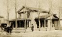
| Date: | 1887 |
|---|---|
| Description: | The Utly Residence, surrounded by a fence, on the north-east corner of Wisconsin and 8th Streets. Built by E.R. Cooley. A man is standing in the center nea... |
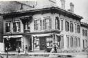
| Date: | 1887 |
|---|---|
| Description: | Northwest corner of Grand Avenue and 4th Street. Built in 1854 at a cost of $18,000. The storefronts were added in 1868; the building razed in 1886. |
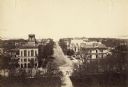
| Date: | 1887 |
|---|---|
| Description: | Elevated view of Wisconsin Avenue from the Wisconsin State Capitol building. Mansions and churches are along the road, and Lake Mendota and Picnic Point ar... |

| Date: | 1887 |
|---|---|
| Description: | View across Park Street towards the northwest of the new Science Hall, shortly after its completion on the University of Wisconsin-Madison campus. Part of ... |

| Date: | 1887 |
|---|---|
| Description: | Exterior of Science Hall on the University of Wisconsin-Madison campus. View from across Park Street taken shortly after completion of new building after f... |

| Date: | 1887 |
|---|---|
| Description: | View up Langdon Street of the new Science Hall on the University of Wisconsin-Madison campus. |

| Date: | 1887 |
|---|---|
| Description: | Elevated view over roof tops of lower campus looking up towards Bascom Hall. Science Hall at the end of Langdon Street is on the right side of Bascom Hill ... |
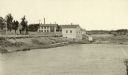
| Date: | 1887 |
|---|---|
| Description: | View of the boom company office and the site of the old trading post. |

| Date: | 1887 |
|---|---|
| Description: | This map shows block numbers, roads, railroads, wards, and selected buildings. The map includes a "Milwaukee city street guide" and index to public buildin... |

| Date: | 1887 |
|---|---|
| Description: | This 1887 map of Price County, Wisconsin, shows the township and range system, sections, railroads, vacant land and land sold by the Wisconsin Central Rail... |

| Date: | 1887 |
|---|---|
| Description: | This 1887 map of Ashland County, Wisconsin, shows the township and range system, sections, railroads, vacant Wisconsin Central Railroad land, state and "go... |

| Date: | 1887 |
|---|---|
| Description: | This 1887 map of Taylor County, Wisconsin, shows the township and range system, sections, railroads, vacant Wisconsin Central Railroad land, land sold by t... |

| Date: | 1887 |
|---|---|
| Description: | This 1896 map shows the township and range system, sections, cities and villages, railroads, roads, vacant land and land sold by the Wisconsin Central Rail... |

| Date: | 1887 |
|---|---|
| Description: | This late 19th century map shows the lake region around Oconomowoc in Waukesha County and eastern Jefferson County, Wisconsin. Cities and villages, roads, ... |
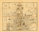
| Date: | 1887 |
|---|---|
| Description: | This map of Beloit shows labeled wards, plat of town, roads, railroads, the Rock River, city boundaries, and land ownership by name. The back of the map is... |

| Date: | 1887 |
|---|---|
| Description: | This map shows lot and block numbers, established dock lines, docks, slips, railroads, and streets of West Superior in 1887. |

| Date: | 1887 |
|---|---|
| Description: | A plat map of Waterford. Township 4, North Range 19, East of 4th Principal Meridian. References at bottom include school houses, houses, churches and cemet... |
If you didn't find the material you searched for, our Library Reference Staff can help.
Call our reference desk at 608-264-6535 or email us at: