Map or Atlas
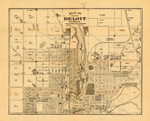
Map of the city of Beloit, Wisconsin

| This map of Beloit shows labeled wards, plat of town, roads, railroads, the Rock River, city boundaries, and land ownership by name. The back of the map is text about the city and the cover reads: "Beautiful Beloit. A Healthful and Picturesque Location. A Thriving Manufacturing City. The Hum of Her Varied Industries Make Music and Money. Superb Water Power, Excellent Railroad Facilities, and Favorable Distributing Advantages. An Inviting Field For Laborer and Capitalist. Modern Improvements and Metropolitan Advantages. Schools, Churches and College Contribute To The Intellectual, Social and Moral Welfare. Reader Listen! If You Want a Home, an Occupation, Prosperity, Happiness, a Long Life, and a Fruitful Life, Come To Beloit! Read the Following." |
| Image ID: | 103718 |
|---|---|
| Creation Date: | circa 1887 |
| Creator Name: | Bergendahl, Charles |
| City: | Beloit |
| County: | Rock |
| State: | Wisconsin |
| Collection Name: | Map Collection |
| Genre: | Map or Atlas |
| Original Format Type: | prints, photomechanical |
| Original Format Number: | GX9029 B46 1887 B |
| Original Dimensions: | 31 x 38 cm., on sheet 36 x 44 cm. |
| Cities and towns |
| Railroads |
| Roads |
| Land |
| This image is issued by the Wisconsin Historical Society. Use of the image requires written permission from the staff of the Collections Division. It may not be sold or redistributed, copied or distributed as a photograph, electronic file, or any other media. The image should not be significantly altered through conventional or electronic means. Images altered beyond standard cropping and resizing require further negotiation with a staff member. The user is responsible for all issues of copyright. Please Credit: Wisconsin Historical Society. |
| Location: | Wisconsin Historical Society Archives, 4th Floor, Madison, Wisconsin |
|---|
