Filter: Categories of Wisconsin Historical Images
Filter: FULL_DATE of 1880
Filter: Subject of service industries
Filter: Subject of architecture
Filter: Categories of Wisconsin Historical Images
Filter: FULL_DATE of 1880
Filter: Subject of service industries
Filter: Subject of architecture
| Date: | 1880 |
|---|---|
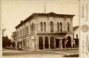
| Description: | The Opera House at the corner of Washington (now Main) and North Mill Streets. A sign at the back of the building reads: "Printing." A barber pole is in fr... |
| Date: | 1880 |
|---|---|
| Description: | 2504 Forest Home Avenue. This hotel was situated on what was originally a plank road between Milwaukee and Muskego. It was designed after the Federal style... |

| Date: | 1880 |
|---|---|
| Description: | Bird's-eye map over the Mississippi River of Fountain City. Paddle steamers and steamboats are on the river, and bluffs are in the background. |
| Date: | 1880 |
|---|---|
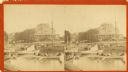
| Description: | Stereograph view of the Whiting House with its large harbor and boats. Whiting House is a four-story wood frame Second Empire style hotel standing on the l... |
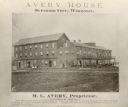
| Date: | 1880 |
|---|---|
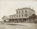
| Description: | Exterior view of the Avery House, with groups of people gathered on its porches and balcony. |

| Date: | 1880 |
|---|---|
| Description: | Stereograph view of the Hutson House, with people standing on its balcony and porch. |
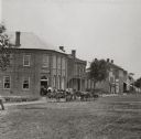
| Date: | 1880 |
|---|---|
| Description: | View of unpaved Water Street, featuring a group of patrons standing in the entrance of A. Becker's Saloon. |
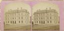
| Date: | 1880 |
|---|---|
| Description: | Stereograph of the old Post Office that was located at the corner of Wisconsin Avenue and Mifflin Street. |
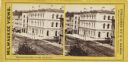
| Date: | 1880 |
|---|---|
| Description: | Stereograph. Elevated view of corner of Milwaukee and Wisconsin Streets. Three-story white building with several chimneys. A horse and cart are on the rig... |

| Date: | 1880 |
|---|---|
| Description: | Map of Wisconsin including the eastern portions on Minnesota, Iowa, northern Illinois, and the western most portion of Michigan’s Upper Peninsula, showing ... |

| Date: | 1880 |
|---|---|
| Description: | Map created from original drawing and surveys taken by Silas Chapman. Bottom right corner features a reference key. There is a street guide on the left sid... |

| Date: | 1880 |
|---|---|
| Description: | An exterior view of the Park Hotel, at the corner of Main and Carroll Streets. Children and adults are standing on the street corner on the left. A large g... |

| Date: | 1880 |
|---|---|
| Description: | This map is pen-and-ink on paper. The map shows buildings, trees, and water and gas pipes, relief is shown by contours. The back of the map reads: "Univers... |
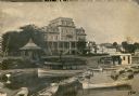
| Date: | 1880 |
|---|---|
| Description: | View from water over boats towards the four-story wood frame Second Empire style Whiting House Hotel standing on the lake shore at Lake Geneva. Several set... |
If you didn't find the material you searched for, our Library Reference Staff can help.
Call our reference desk at 608-264-6535 or email us at: