 Filter: Categories of Wisconsin Historical Images
Filter: FULL_DATE of 1880
Filter: Subject of human settlements
Filter: Categories of Wisconsin Historical Images
Filter: FULL_DATE of 1880
Filter: Subject of human settlements
| Date: | 1880 |
|---|---|
| Description: | This plat of Vanceburg Cemetery, Town of Sheridan, Dunn County, Wisconsin, likely dates from the 1880s and "is intended for the correction of names of peop... |

| Date: | 1880 |
|---|---|
| Description: | Map created from original drawing and surveys taken by Silas Chapman. Bottom right corner features a reference key. There is a street guide on the left sid... |

| Date: | 1880 |
|---|---|
| Description: | An exterior view of the Park Hotel, at the corner of Main and Carroll Streets. Children and adults are standing on the street corner on the left. A large g... |
| Date: | 1880 |
|---|---|
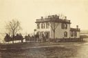
| Description: | View across lawn of the residence of Lucius Fairchild, in Madison. A woman is standing outdoors near the entrance. A fence surrounds the yard of the house,... |

| Date: | 1880 |
|---|---|
| Description: | This map of La Crosse shows the Chicago, Milwaukee and St. Paul Railroad, the Southern Minnesota Railroad and the Chicago, Dubuque and Minnesota Railroad, ... |

| Date: | 1880 |
|---|---|
| Description: | This map of the southern part of La Crosse is pen on cloth and shows proposed streets crossing the lands of Jane Usher and the Green Bay, Winona and St. Pa... |

| Date: | 1880 |
|---|---|
| Description: | View of flood damage, showing wrecked buildings along the Wisconsin River waterfront. |

| Date: | 1880 |
|---|---|
| Description: | View along Central Avenue. There are a number of commercial buildings with false fronts. Groups of people stand near the road on the left and right. |
| Date: | 1880 |
|---|---|
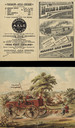
| Description: | Front and back of 4-panel brochure. Features an illustration of the factory on the front cover. On the inside a 2-page spread features a color illustration... |

| Date: | 1880 |
|---|---|
| Description: | This map covers parts of Minnesota, Iowa, and South Dakota and advertised 1,000,000 acres of land available. Communities, roads, and railroad lines are lab... |

| Date: | 1880 |
|---|---|
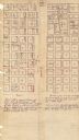
| Description: | This map shows wards, roads, railroads, lot and block numbers, subdivisions, parks, and some landownership. A handwritten annotation in red reads: "Note: S... |
| Date: | 1880 |
|---|---|
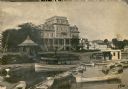
| Description: | View from water over boats towards the four-story wood frame Second Empire style Whiting House Hotel standing on the lake shore at Lake Geneva. Several set... |

| Date: | 1880 |
|---|---|
| Description: | This blueprint map shows proposed railroad tracks between Carroll Street and Wisconsin Avenue along Lake Monona. |

| Date: | 1880 |
|---|---|
| Description: | Stereograph of a boarding house in the woods surrounded by a pole fence. Hand-written on the reverse: "First Boarding house of Florence, Erected March 1st,... |

| Date: | 1880 |
|---|---|
| Description: | A halftone print copy of a photograph of George Brumder's 1873 three story brick building at 286-288 West Water Street. Brumder and his family lived on the... |
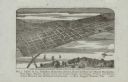
| Date: | 1880 |
|---|---|
| Description: | Bird's-eye map of the city of Madison. Caption reads: "City of Madison — From Park's 'History of Madison, Dane County, and Surrounding Towns.'" The text un... |

| Date: | 1880 |
|---|---|
| Description: | A map of Milwaukee which includes a city street guide. |
If you didn't find the material you searched for, our Library Reference Staff can help.
Call our reference desk at 608-264-6535 or email us at: