 Filter: Categories of Wisconsin Historical Images
Filter: FULL_DATE of 1879
Filter: Subject of streets
Filter: Categories of Wisconsin Historical Images
Filter: FULL_DATE of 1879
Filter: Subject of streets
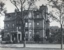
| Date: | 1879 |
|---|---|
| Description: | The facade of the McCormick family residence at 675 Rush Street, which takes up an entire block between Erie and Huron Streets. Cyrus Hall McCormick, Sr. h... |

| Date: | 1879 |
|---|---|
| Description: | This map is a bird's-eye view of Wausau, the County Seat of Marathon County. The map features an index of points of interest. |
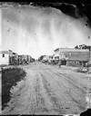
| Date: | 1879 |
|---|---|
| Description: | View of a main street looking towards The Fulton Meat Market, P. Carrington Harness shop, a livery stable, feed store, restaurant and bakery. |

| Date: | 1879 |
|---|---|
| Description: | This bird’s-eye-view map is a photostat copy of the orginal and is indexed for points of interest. Streets are labeled as well as the Barbaoo River. |

| Date: | 1879 |
|---|---|
| Description: | This map shows asylums, cemeteries, hospitals, parks, streets, and wards. Relief is shown by contours. Also included are manuscript annotations in pencil. ... |

| Date: | 1879 |
|---|---|
| Description: | This map shows wards, sections, roads, lot and block numbers, subdivisions, and proposed streets. The inside cover includes hand written annotations that r... |
If you didn't find the material you searched for, our Library Reference Staff can help.
Call our reference desk at 608-264-6535 or email us at: