 Filter: Categories of Wisconsin Historical Images
Filter: FULL_DATE of 1873
Filter: Subject of streets
Filter: Categories of Wisconsin Historical Images
Filter: FULL_DATE of 1873
Filter: Subject of streets
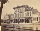
| Date: | 1873 |
|---|---|
| Description: | Ellsworth Block on North Pinckney Street between East Washington and East Mifflin Streets as seen from the Capitol Park. Storefronts include the Dry Goods ... |

| Date: | 1873 |
|---|---|
| Description: | Bird's-eye map of La Crosse from the Mississippi River. |
| Date: | 1873 |
|---|---|
| Description: | Locomotive, with view east on West Washington Avenue toward the Wisconsin State Capitol. There is a sign near the tracks that reads: "Look Out for The Cars... |
| Date: | 1873 |
|---|---|
| Description: | Elevated view of employees, along with young children, posed around a wagon loaded with barrels of beer in front of Hausmann's Capital Brewery at the corne... |
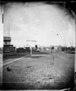
| Date: | 1873 |
|---|---|
| Description: | Elevated view of South Pinckney Street from the Wisconsin State Capitol, with East Washington Avenue to the left and Lake Monona on the distant right. The ... |
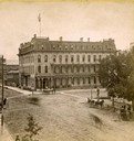
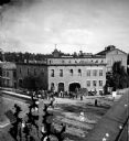
| Date: | 1873 |
|---|---|
| Description: | Elevated view of the Park Hotel at the intersection of Carroll and Main streets, with the Capitol Park on the right. Several carriages are hitched at the p... |

| Date: | 1873 |
|---|---|
| Description: | A group posed on the porch of the Middleton House, a two-story frame building with lattice and cut work, located across the intersection from J. Green & Co... |

| Date: | 1873 |
|---|---|
| Description: | Slightly elevated engraved view of the Walworth County Courthouse. In the foreground a man is riding a horse along the street. Pedestrians are on the groun... |
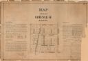
| Date: | 1873 |
|---|---|
| Description: | A plat of the village of Greenleaf, Brown County, Wisconsin, showing the areas from Taintor Street to Day Street and Follett Street to Deuster Street. Inc... |

| Date: | 1873 |
|---|---|
| Description: | This map shows lots and blocks, additions and subdivisions, and large-scale landownership. The map is oriented with north to the upper right. The map is fr... |

| Date: | 1873 |
|---|---|
| Description: | This map shows land ownership by name, local streets, railroads, parks, college grounds, schools, cemeteries, and part of Rock River. The upper left margin... |
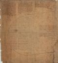
| Date: | 1873 |
|---|---|
| Description: | This map is pen-and-ink on cloth and shows lot numbers, block letters, streets, West Wis. Railway, Hudson City Mills, and Lake St. Croix. Also included are... |

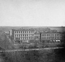
| Date: | 1873 |
|---|---|
| Description: | Elevated view from Capitol Park of Madison City Hall with clock tower, 2 West Mifflin Street. Lake Mendota is in the far background. |
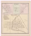
| Date: | 1873 |
|---|---|
| Description: | A page showing four plat maps: Stoughton, Clifton, Deanville, and Cross Plains. |
If you didn't find the material you searched for, our Library Reference Staff can help.
Call our reference desk at 608-264-6535 or email us at: