Filter: Categories of Wisconsin Historical Images
Filter: FULL_DATE of 1873
Filter: Subject of human settlements
Filter: Creator Name of Unknown
Filter: Categories of Wisconsin Historical Images
Filter: FULL_DATE of 1873
Filter: Subject of human settlements
Filter: Creator Name of Unknown

| Date: | 1873 |
|---|---|
| Description: | Map of the township of Windsor, from the "Atlas of Dane County." |

| Date: | 1873 |
|---|---|
| Description: | Newspaper reproduction of an etching of the Milwaukee River. |

| Date: | 1873 |
|---|---|
| Description: | The harbor, showing the sidewheel packet, "Belle of La Crosse," and the sidewheel ferry "Alex McGregor." Other boats are also seen including two barges loa... |
| Date: | 1873 |
|---|---|
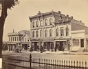
| Description: | Ellsworth Block on North Pinckney Street between East Washington and East Mifflin Streets as seen from the Capitol Park. Storefronts include the Dry Goods ... |
| Date: | 1873 |
|---|---|
| Description: | Elevated view of South Pinckney Street from the Wisconsin State Capitol, with East Washington Avenue to the left and Lake Monona on the distant right. The ... |
| Date: | 1873 |
|---|---|
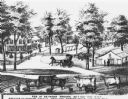
| Description: | Downtown East Troy with the Seymour Brooks residence. Caption reads: "Res. of Seymour brooks, Sec 4 Fast Troy TP Wis Breeder of Derham Cattle American Meri... |

| Date: | 1873 |
|---|---|
| Description: | An advertisement for John N. Jones, Dealer in Hardware, which appeared in the 1873 Madison City Directory. |
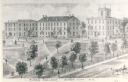
| Date: | 1873 |
|---|---|
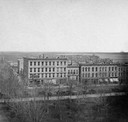
| Description: | View of several buildings on the grounds of Ripon College. Caption reads: "Ripon College, Ripon City, Wis." |

| Date: | 1873 |
|---|---|
| Description: | Portion of Winnebago County map showing Lake Winneconne and the Wolf River. |

| Date: | 1873 |
|---|---|
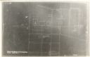
| Description: | This map shows lots and blocks, additions and subdivisions, and large-scale landownership. The map is oriented with north to the upper right. The map is fr... |

| Date: | 1873 |
|---|---|
| Description: | A map of the township of Primrose from the "Atlas of Dane County." |

| Date: | 1873 |
|---|---|
| Description: | A map of the township of Montrose from the "Atlas of Dane County." |

| Date: | 1873 |
|---|---|
| Description: | Elevated view from Capitol Park of Madison City Hall with clock tower, 2 West Mifflin Street. Lake Mendota is in the far background. |
If you didn't find the material you searched for, our Library Reference Staff can help.
Call our reference desk at 608-264-6535 or email us at: