 Filter: Categories of Wisconsin Historical Images
Filter: FULL_DATE of 1870
Filter: Subject of roads
Filter: Categories of Wisconsin Historical Images
Filter: FULL_DATE of 1870
Filter: Subject of roads

| Date: | 1870 |
|---|---|
| Description: | This bird's-eye-view map shows roads, a river with boats, and homes. The bottom margin of the map includes an index. |
| Date: | 1870 |
|---|---|
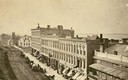
| Description: | Buildings along Wisconsin Avenue lining a wide dirt road. |

| Date: | 1870 |
|---|---|
| Description: | Baraboo was first settled around 1838, and by 1870 it had become the county seat and the thriving village illustrated here. This birds eye drawing depicts ... |

| Date: | 1870 |
|---|---|
| Description: | Although the first European settlement in Jefferson was in 1836, the Village of Jefferson was first incorporated as a city in 1878. Made eight years earlie... |

| Date: | 1870 |
|---|---|
| Description: | Bird's-eye map of Prairie du Sac. |

| Date: | 1870 |
|---|---|
| Description: | Sauk City is the oldest incorporated village in Wisconsin (incorporated in 1854) and also has the oldest organized volunteer fire department in the state, ... |

| Date: | 1870 |
|---|---|
| Description: | Bird's-eye map of Kilbourn City, now known as Wisconsin Dells. Kilbourn City was platted in the 1850s and received a boost when the La Crosse and Milwaukee... |

| Date: | 1870 |
|---|---|
| Description: | Birds-eye drawing of Oconomowoc depicts street names and street layouts, houses, trees, Oconomowoc River, Fowler Lake, and La Belle Lake. A reference key a... |

| Date: | 1870 |
|---|---|
| Description: | Bird's-eye view of Whitewater, with insets. |
| Date: | 1870 |
|---|---|
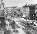
| Description: | View overlooking Pinckney Street on the Square with the American Hotel in the background. |
| Date: | 1870 |
|---|---|
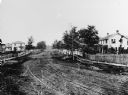
| Description: | View of dirt road with houses along both sides, and wooden walkways and picket fences along the road. |

| Date: | 1870 |
|---|---|
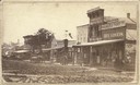
| Description: | View of the California house next to a store with a sign that reads: "M. Silber & Bro.," and a "Boot & Shoe Store." A bakery is on the left, and a group of... |
| Date: | 1870 |
|---|---|
| Description: | View down road towards the Western Hotel on the left. The original tavern was built in 1834 (?) by William Shields (?). In 1845 it was operated by his son ... |
| Date: | 1870 |
|---|---|
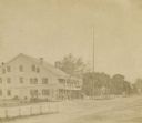
| Description: | West side view of the Courthouse Square, with Hassinger & Chandler Dry Goods in the foreground. |
| Date: | 1870 |
|---|---|
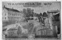
| Description: | An advertisement featuring Wauwatosa, showing the First Baptist Church, on the left, built in 1854 and the First Congregational Church, on the right built ... |
| Date: | 1870 |
|---|---|
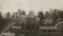
| Description: | View over rooftops towards the primitive Methodist Church, which is surrounded by homes. |
If you didn't find the material you searched for, our Library Reference Staff can help.
Call our reference desk at 608-264-6535 or email us at:


