 Filter: Categories of Wisconsin Historical Images
Filter: FULL_DATE of 1870
Filter: Subject of land
Filter: Categories of Wisconsin Historical Images
Filter: FULL_DATE of 1870
Filter: Subject of land
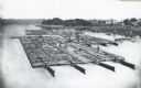
| Date: | 1870 |
|---|---|
| Description: | Elevated view of lumber raft and workers on the Chippewa River. In the background on the right are dwellings. |

| Date: | 1870 |
|---|---|
| Description: | Baraboo was first settled around 1838, and by 1870 it had become the county seat and the thriving village illustrated here. This birds eye drawing depicts ... |

| Date: | 1870 |
|---|---|
| Description: | Bird's-eye map of Hudson, with insets of Court House and Public School. |

| Date: | 1870 |
|---|---|
| Description: | Although the first European settlement in Jefferson was in 1836, the Village of Jefferson was first incorporated as a city in 1878. Made eight years earlie... |

| Date: | 1870 |
|---|---|
| Description: | Bird's-eye map of Prairie du Sac. |

| Date: | 1870 |
|---|---|
| Description: | Sauk City is the oldest incorporated village in Wisconsin (incorporated in 1854) and also has the oldest organized volunteer fire department in the state, ... |

| Date: | 1870 |
|---|---|
| Description: | Bird's-eye map of Kilbourn City, now known as Wisconsin Dells. Kilbourn City was platted in the 1850s and received a boost when the La Crosse and Milwaukee... |

| Date: | 1870 |
|---|---|
| Description: | Bird's-eye view of the city of Manitowoc with a population of 5,168 inhabitants as it appears in 1870, the year the village was granted a city charter by t... |

| Date: | 1870 |
|---|---|
| Description: | Birds-eye drawing of Oconomowoc depicts street names and street layouts, houses, trees, Oconomowoc River, Fowler Lake, and La Belle Lake. A reference key a... |
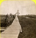
| Date: | 1870 |
|---|---|
| Description: | Boardwalk leading to St. Joseph's Catholic Church in La Pointe. |
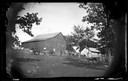
| Date: | 1870 |
|---|---|
| Description: | Men, horses and wagons on a hillside. A barn and another building are in the background. |

| Date: | 1870 |
|---|---|
| Description: | A carriage and a family stand in front of a picket fence in front of an unpainted Greek Revival frame house. Attached to the house is a storefront. Althoug... |

| Date: | 1870 |
|---|---|
| Description: | Group of people sitting beside spring, perhaps at Winnequah or Picnic Point in Madison. All of them are either holding or are wearing hats. |
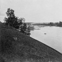
| Date: | 1870 |
|---|---|
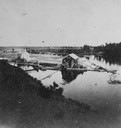
| Description: | Overlook of the river, and a building near the dam from a steep hillside. |
| Date: | 1870 |
|---|---|
| Description: | View from a hillside of either houses or factory buildings on the Fox River near a dam. |
| Date: | 1870 |
|---|---|
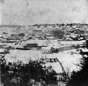
| Description: | Elevated view of Chippewa Falls during the winter. |
If you didn't find the material you searched for, our Library Reference Staff can help.
Call our reference desk at 608-264-6535 or email us at:


