Filter: Categories of Wisconsin Historical Images
Filter: FULL_DATE of 1870
Filter: Subject of human settlements
Filter: Subject of cities and towns
Filter: Categories of Wisconsin Historical Images
Filter: FULL_DATE of 1870
Filter: Subject of human settlements
Filter: Subject of cities and towns
| Date: | 1870 |
|---|---|
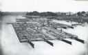
| Description: | Elevated view of lumber raft and workers on the Chippewa River. In the background on the right are dwellings. |
| Date: | 1870 |
|---|---|
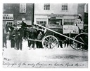
| Description: | Street parade rig, apparently to agitate against delays in construction of a railroad to connect Manitowoc to the west. In the background is a store owned ... |

| Date: | 1870 |
|---|---|
| Description: | During the War of 1812, the only battle fought in Wisconsin was in Prairie du Chien, in 1814. Made fifty-six years later, this birds eye drawing depicts th... |
| Date: | 1870 |
|---|---|
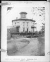
| Description: | The third Wisconsin State Capitol as it appeared during the early 1870s. Close scrutiny of the entrance (whether it is the north or south entrance cannot b... |
| Date: | 1870 |
|---|---|
| Description: | Group of people posing outside of Soldiers' Orphans Home, located on Spaight Street between Paterson and Brearly Streets. The building was originally const... |
| Date: | 1870 |
|---|---|
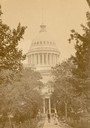
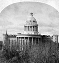
| Description: | Elevated view over trees toward the third (second in Madison), Wisconsin State Capitol that stood from 1857-1913, from a stereograph original. Elevated vie... |
| Date: | 1870 |
|---|---|
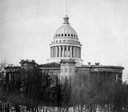
| Description: | The third Wisconsin State Capitol (second in Madison), surrounded by trees. When construction on the capitol was completed in 1868, the structure measured ... |

| Date: | 1870 |
|---|---|
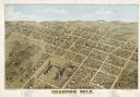
| Description: | Baraboo was first settled around 1838, and by 1870 it had become the county seat and the thriving village illustrated here. This birds eye drawing depicts ... |

| Date: | 1870 |
|---|---|
| Description: | Birds eye drawing of Fort Atkinson, Jefferson County, depicts street names and street layouts, houses, trees, Rock River and Bark River. A reference key at... |

| Date: | 1870 |
|---|---|
| Description: | Bird's-eye map of Hudson, with insets of Court House and Public School. |

| Date: | 1870 |
|---|---|
| Description: | Although the first European settlement in Jefferson was in 1836, the Village of Jefferson was first incorporated as a city in 1878. Made eight years earlie... |

| Date: | 1870 |
|---|---|
| Description: | Bird's-eye map of Prairie du Sac. |

| Date: | 1870 |
|---|---|
| Description: | Bird's-eye map of Madison. The Lakeside House resort is in the foreground, which burned in 1877, in what is now Olin Park. |

| Date: | 1870 |
|---|---|
| Description: | Bird's-eye view of the city of Manitowoc with a population of 5,168 inhabitants as it appears in 1870, the year the village was granted a city charter by t... |

| Date: | 1870 |
|---|---|
| Description: | Bird's-eye view of Whitewater, with insets. |
| Date: | 1870 |
|---|---|
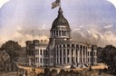
| Description: | The third Wisconsin Capitol (the second in Madison) as it appeared shortly after the construction was completed. |
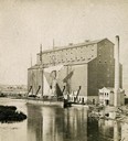
| Date: | 1870 |
|---|---|
| Description: | The Milwaukee & St. Paul Railway Company grain elevator at the Milwaukee harbor, with a sailing ship anchored nearby. |
If you didn't find the material you searched for, our Library Reference Staff can help.
Call our reference desk at 608-264-6535 or email us at: