 Filter: Categories of Wisconsin Historical Images
Filter: FULL_DATE of 1868
Filter: Subject of transportation
Filter: Categories of Wisconsin Historical Images
Filter: FULL_DATE of 1868
Filter: Subject of transportation

| Date: | 1868 |
|---|---|
| Description: | This 1868 birds-eye view depicts the buildings, streets, railroad, vegetation and topography of Columbus, Wisconsin. The high school, cemetery, railroad de... |
| Date: | 1868 |
|---|---|
| Description: | Mineral Point from a carte-de-visite by the "practical photographer." |
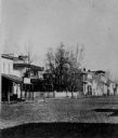
| Date: | 1868 |
|---|---|
| Description: | View of the west side of unpaved Water Street, looking south. |
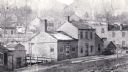
| Date: | 1868 |
|---|---|
| Description: | View of unpaved Water Street, showing a millinery shop. |

| Date: | 1868 |
|---|---|
| Description: | Elevated view up Wisconsin Avenue showing City Hall on the corner at Mifflin Street on the left, with the Post Office to the right. Further down is the Pre... |

| Date: | 1868 |
|---|---|
| Description: | Stereograph view of the levee, with buildings along the left. Signs on the buildings read, left to right: "(?) Hotel", "Saloon" and "Dunbar's Hall." People... |

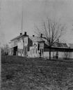
| Date: | 1868 |
|---|---|
| Description: | The Philteus Sawyer residence located on the northwest corner of Algoma and West Algoma Streets. Sawyer was mayor of Oshkosh from 1863-1864, and became a U... |

| Date: | 1868 |
|---|---|
| Description: | Stereograph of an elevated view of the Vilas House hotel, East Main Street at Monona Avenue. |

| Date: | 1868 |
|---|---|
| Description: | The river steamer Chippewa drawn up alongside shore on the West Eau Claire Levee. The steamer was built by Captain E.E. Heerman at La Crosse in 1866... |

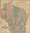
| Date: | 1868 |
|---|---|
| Description: | Prepared for the State Board of Emigration in 1868, this map shows county boundaries, some cities, and completed and projected railroads. |

| Date: | 1868 |
|---|---|
| Description: | This map is one of the earliest weather maps of the United States, which traced an 1859 storm across the continent. Manuscript annotations in red ink show ... |
| Date: | 1868 |
|---|---|
| Description: | This map shows railroads, counties and towns and includes a township grid. Sections are shown in blue, green, yellow, and pink. Rivers and lakes are labele... |

| Date: | 1868 |
|---|---|
| Description: | This map shows the configurations of the counties, communities, railroads and projected railroads, mines, shipping routes, and labeled rivers and lakes. Po... |

| Date: | 1868 |
|---|---|
| Description: | This map includes a table of estimated costs "by Brev. Maj. Gen. G.K. Warren Maj. U.S.E., of improvement of Wis. River from his survey of 1867." Included a... |
If you didn't find the material you searched for, our Library Reference Staff can help.
Call our reference desk at 608-264-6535 or email us at: