 Filter: Categories of Wisconsin Historical Images
Filter: FULL_DATE of 1865
Filter: Subject of military art and science
Filter: Categories of Wisconsin Historical Images
Filter: FULL_DATE of 1865
Filter: Subject of military art and science
| Date: | 1865 |
|---|---|
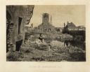
| Description: | The ruins of Charleston after General Sherman's men burned the town near the end of the Civil War. A man, smoking a pipe, and a boy sit on the shoreline of... |
| Date: | 1865 |
|---|---|
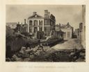
| Description: | Ruins of the Pinckney Mansion with rubble in the street after General Sherman's men burned the town near the end of the Civil War. Plate 59 |

| Date: | 1865 |
|---|---|
| Description: | Exterior of Fort Sumpter [sic]. There are several men and a boat on the shoreline in the foreground. Plate 56 |
| Date: | 1865 |
|---|---|
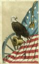
| Description: | Old Abe, eagle mascot of the 8th Wisconsin Regiment. Popular cards sold in great quantities as benefit items ($9 per 100), so great was this bird's fame. ... |
| Date: | 1865 |
|---|---|
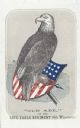
| Description: | Old Abe, eagle mascot of the 8th Wisconsin Regiment. Popular cards sold in great quantities as benefit items ($9 per 100), so great was this bird's fame. ... |
| Date: | 1865 |
|---|---|
| Description: | Title page of "The Soldier Bird!" — History of "Old Abe" the live war eagle. |

| Date: | 1865 |
|---|---|
| Description: | Studio portrait of David G. James holding a large, over the shoulder horn, and a hat. |

| Date: | 1865 |
|---|---|
| Description: | This map of Maryland and Virginia shows railroads, rivers, cities and towns, and the positions of Confederate troops and defenses in Virginia in 1861. |

| Date: | 1865 |
|---|---|
| Description: | This map is a pen and ink tracing. Union positions are shown in blue and Confederate positions are shown in red. Roads, vegetation, and streams are labeled... |

| Date: | 1865 |
|---|---|
| Description: | This map of the battlefield at Spotsylvania Courthouse illustrates the Union positions in blue and Confederate positions in red. Roads, railroads, vegetati... |
| Date: | 1865 |
|---|---|
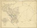
| Description: | This map traces the route of Union troops under the command of Gen. William S. Smith. This force left Memphis, Tennessee, on February 11, 1864, traveling a... |
| Date: | 1865 |
|---|---|
| Description: | This map of the battlefield shows U.S. infantry positions in blue, U.S. cavalry positions in yellow, Confederate positions in red, roads, drainage, vegetat... |

| Date: | 1865 |
|---|---|
| Description: | This map of the battlefield at Five Forks, Va., shows Union and Confederate positions, roads, drainage, vegetation, relief by hachures, and names of reside... |
| Date: | 1865 |
|---|---|
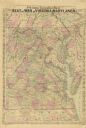
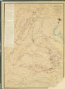
| Description: | A general map of eastern Virginia, Maryland, Delaware, southern Pennsylvania, and northern North Carolina. |

| Date: | 1865 |
|---|---|
| Description: | Detailed map of the southeastern United States showing fortifications, "movements of Genl. J.H. Wilson's Cavalry Corps," "pursuit of Hood" and the lines of... |

| Date: | 1865 |
|---|---|
| Description: | Map extends from Harper's Ferry in the north to Petersburg in the south and from Lexington east to Heathsville. The routes of the II, V, VI, IX, XVIII, and... |

| Date: | 1865 |
|---|---|
| Description: | This detailed map of the area between Richmond and Petersburg shows fortifications, roads, railroads, towns, street patterns of Petersburg and Richmond, dr... |
| Date: | 1865 |
|---|---|
| Description: | This map shows the seven raids made in central Virginia by cavalry under the command of Maj. Gen. Philip H. Sheridan between May 9, 1864, and May 3, 1865. |

| Date: | 1865 |
|---|---|
| Description: | This pen and ink map sketches the route taken by General Sherman's troops from Atlanta, Georgia, to Savannah, Georgia. Railroads, rivers, and towns are lab... |

| Date: | 1865 |
|---|---|
| Description: | The map of the battlefield shows entrenchments, villages, roads, the "South Side Rail Road" drainage, vegetation, relief by hachures, houses, and names of ... |
If you didn't find the material you searched for, our Library Reference Staff can help.
Call our reference desk at 608-264-6535 or email us at: