 Filter: Categories of Wisconsin Historical Images
Filter: FULL_DATE of 1861
Filter: Categories of Wisconsin Historical Images
Filter: FULL_DATE of 1861
| Date: | 1861 |
|---|---|
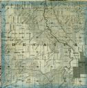
| Description: | A detail from a map of Green County, showing only Decatur. |

| Date: | 1861 |
|---|---|
| Description: | A general map of Pennsylvania, Virginia, New Jersey and Delaware. Insets include maps of New Orleans, Baltimore, St. Louis, Charleston, Savannah, Washingto... |

| Date: | 1861 |
|---|---|
| Description: | This map was reproduced photographically and issued in Augusta, Ga., in the early days of the Civil War. It includes panels showing Virginia, Maryland, the... |

| Date: | 1861 |
|---|---|
| Description: | Shows townships and sections, landowners, and woodlands. Includes inset maps of Monroe, Brodhead, Albany, Cadiz, Decatur, Dayton, Clarence, Springfield, Tw... |

| Date: | 1861 |
|---|---|
| Description: | This map shows Manassas during the First Battle of Bull Run, in which the 2nd Wisconsin Infantry fought, and the Leesburg area, the site of the Battle of B... |

| Date: | 1861 |
|---|---|
| Description: | This map of the entire state of Wisconsin depicts the township survey grid and identifies counties, named towns, cities and villages, rivers, lakes, railro... |

| Date: | 1861 |
|---|---|
| Description: | This 1861 map of Columbia County, Wisconsin, shows the township and range grid, towns, sections, cities and villages, railroads, roads, property owners and... |

| Date: | 1861 |
|---|---|
| Description: | Shows townships and sections, landowners, and woodlands. Includes inset maps of Monroe, Brodhead, Albany, Cadiz, Decatur, Dayton, Clarence, Springfield, Tw... |

| Date: | 1861 |
|---|---|
| Description: | Map with labelled block and lot numbers, owners of large property parcels, city wards, railroads, and streets. Population from 1835 to 1860 listed below ti... |

| Date: | 1861 |
|---|---|
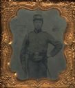
| Description: | Sixth plate ferrotype/tintype of an unidentified soldier from the 13th Wisconsin Infantry. Hand-coloring on cheeks and gold details on buttons of military ... |

| Date: | 1861 |
|---|---|
| Description: | Sixth plate tintype/ferrotype of an unidentified soldier from the 13th Wisconsin Infantry. He is sitting in a chair holding a horn in his right hand. Hand-... |

| Date: | 1861 |
|---|---|
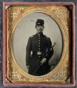
| Description: | Sixth plate tintype/ferrotype portrait of an unidentified soldier from the 13th Wisconsin Infantry. The man is seated with his arm draped over the back of ... |

| Date: | 1861 |
|---|---|
| Description: | Depths shown by soundings. Shows township and sections, landownership and acreages, roads, railroads, and buildings. "Entered according to Act of Congress ... |

| Date: | 1861 |
|---|---|
| Description: | Quarter plate full-length military portrait of Harlow Milton Waller, facing forward with right hand holding his sword at his side. The portrait is hand tin... |

| Date: | 1861 |
|---|---|
| Description: | The township of Primrose, which is a detail from the plat map of Dane County. |

| Date: | 1861 |
|---|---|
| Description: | The township of Montrose, which is a detail from a Dane County plat map. |
| Date: | 1861 |
|---|---|
| Description: | Sixth plate ferrotype/tintype of Burnett Demarest, a First Lieutenant in the Wisconsin 8th infantry, Co. C. Demarest mustered into service in 1861 at Eau C... |

| Date: | 1861 |
|---|---|
| Description: | This map shows lot and block numbers, piers, streets, monuments, and township section corners. Included is a note on the width of avenues, piers, slips, al... |
| Date: | 1861 |
|---|---|
| Description: | Sixth plate ferrotype/tintype of a Civil War Soldier. Three-quarter length portrait, perhaps Captain Edward Devlin, of Mineral Point, holding a sword. He s... |

| Date: | 1861 |
|---|---|
| Description: | Shaded drawings with size dimensions for plans of "Tents used in Civil War. U.S. Army Regulation Tents." Upper left, "18. ft diam, Gilbert Anderson Hub... |
If you didn't find the material you searched for, our Library Reference Staff can help.
Call our reference desk at 608-264-6535 or email us at: