 Filter: Categories of Wisconsin Historical Images
Filter: FULL_DATE of 1857
Filter: Subject of architecture
Filter: Categories of Wisconsin Historical Images
Filter: FULL_DATE of 1857
Filter: Subject of architecture
| Date: | 1857 |
|---|---|
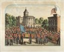
| Description: | A lithographic portrait by Louis Kurz (1833-1921) of Madison Fire Engine Company #2 posed with a hand pumper and hose cart in front of the design of the ne... |
| Date: | 1857 |
|---|---|
| Description: | Lithograph of the Wisconsin State Capitol, surrounded by portraits of Wisconsin Statesmen. Governor Bashford hired the Madison architectural firm Kutzbock ... |
| Date: | 1857 |
|---|---|
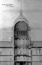
| Description: | Section drawing of the rotunda of the third Wisconsin State Capitol (second in Madison) by Stephen V. Shipman. August Kutzbock and Samuel H. Donnel were th... |

| Date: | 1857 |
|---|---|
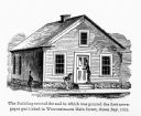
| Description: | From Judge Smith Addition, 5th Ward, looking north, toward the city. Drawing is an elevated view of field and plank fence in foreground, road to the left a... |

| Date: | 1857 |
|---|---|
| Description: | Bird's-eye view of Madison over rooftop and across lake with sailboats and steamers. A group of people are standing on a viewing platform on the roof in th... |
| Date: | 1857 |
|---|---|
| Description: | Business with Frank Leslie's Illustrated Newspaper took Hölzlhuber to New York, and from there he also visited Philadelphia, Baltimore, and Washingt... |
| Date: | 1857 |
|---|---|
| Description: | Green Bay Intelligencer Newspaper Office. This was the first newspaper published in Wisconsin. The building was on Main Street. This drawing appeared in an... |

| Date: | 1857 |
|---|---|
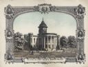
| Description: | Illustration of an early design for the 3rd Wisconsin State Capitol, the second in Madison. Caption reads: "State Capitol at Madison — Donnel & Kutzbock, A... |

| Date: | 1857 |
|---|---|
| Description: | A quarter section of a map of the city of Fond du Lac. This section features an illustration of Amory Hall and the Exchange Bank of Darling & Co. |
| Date: | 1857 |
|---|---|
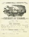
| Description: | Membership certificate of the Athenaen Society of the University of Wisconsin presented to Charles Fairchild in 1857. The society was a student literary an... |

| Date: | 1857 |
|---|---|
| Description: | This map shows section corners, quarter section corners, foundry, steam saw mill, steam grist mill, planning mill, court house, baptist church, congregatio... |

| Date: | 1857 |
|---|---|
| Description: | This map shows lot and block numbers, wards, roads, railroads, some landowners’ names, and selected buildings. The map includes an inset map of Glidden & L... |

| Date: | 1857 |
|---|---|
| Description: | This map shows lot and block numbers, wards, roads, railroads, some landowners’ names, and selected buildings. Lake Michigan, the Milwaukee River, and Glid... |

| Date: | 1857 |
|---|---|
| Description: | This map shows lot and block numbers, wards, roads, railroads, some landowners’ names, and selected buildings. Lake Michigan, the Milwaukee River, and Glid... |

| Date: | 1857 |
|---|---|
| Description: | This map shows land ownership by name, local streets, wards, buildings, parks, a cemetery, and part of Lake Michigan. Depths are shown by soundings and nor... |

| Date: | 1857 |
|---|---|
| Description: | This map shows rural landownership and acreages, lot and block numbers, selected buildings, roads, railroads, and public squares. The map is indexed for th... |
| Date: | 1857 |
|---|---|
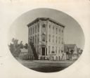
| Description: | Oval-framed view from street of the corner bank building at 111 S. Hamilton Street, with houses on the left and right. The main business is Millers Bank In... |

| Date: | 1857 |
|---|---|
| Description: | This map shows roads, railroads, lakes, and land ownership by name. Also included are illustrations of select business and residences, business directories... |

| Date: | 1857 |
|---|---|
| Description: | Elevated view from the Wisconsin State Capitol up State Street to Bascom Hall. There is a fence around the capitol grounds, and pedestrians are walking on ... |

| Date: | 1857 |
|---|---|
| Description: | This map shows lot and block numbers, streets, railroad depots, locks, bridges, dams, canals, U.S. light house, college grounds, a steam boat landing, and ... |
If you didn't find the material you searched for, our Library Reference Staff can help.
Call our reference desk at 608-264-6535 or email us at: