 Filter: Categories of Wisconsin Historical Images
Filter: FULL_DATE of 1856
Filter: Subject of service industries
Filter: Categories of Wisconsin Historical Images
Filter: FULL_DATE of 1856
Filter: Subject of service industries

| Date: | 1856 |
|---|---|
| Description: | The Ludemann's [also spelled Lueddemann] farm had been cultivated since the early 1850s by Mr. Ludemann, "a very pleasant Saxon with his very pleasant wife... |

| Date: | 1856 |
|---|---|
| Description: | A hand-colored map of Wisconsin, showing the county boundaries, towns, cities, railroads, roads, lakes, rivers, bays, and the Lake Superior’s islands. In ... |

| Date: | 1856 |
|---|---|
| Description: | This map is ink and watercolor on tracing paper and shows plat of city, local streets, block numbers, topography, several buildings, and includes an explan... |
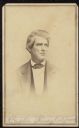
| Date: | 1856 |
|---|---|
| Description: | Vignetted waist-up carte-de-visite portrait of Pliney [some sources spell it "Pliny"] Alford, a riverboat captain on the Mississippi River. Caption reads: ... |
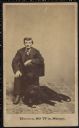
| Date: | 1856 |
|---|---|
| Description: | Carte-de-visite of Joseph Mabbett Allcott, proprietor of J.M. Allcott & Co. drug store in Milwaukee. He is sitting in a chair, with a dog resting at his fe... |
If you didn't find the material you searched for, our Library Reference Staff can help.
Call our reference desk at 608-264-6535 or email us at: