 Filter: Categories of Wisconsin Historical Images
Filter: FULL_DATE of 1856
Filter: Subject of michigan, lake
Filter: Categories of Wisconsin Historical Images
Filter: FULL_DATE of 1856
Filter: Subject of michigan, lake

| Date: | 1856 |
|---|---|
| Description: | This map show the surveyed southern part of state and includes "profile of the Milwaukee and Mississippi Rail Road." Counties are shown in pink, green, blu... |

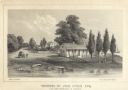
| Date: | 1856 |
|---|---|
| Description: | The Ludemann's [also spelled Lueddemann] farm had been cultivated since the early 1850s by Mr. Ludemann, "a very pleasant Saxon with his very pleasant wife... |

| Date: | 1856 |
|---|---|
| Description: | Wisconsin map illustrating the Mineral Point Railroad and its connections. |

| Date: | 1856 |
|---|---|
| Description: | View of Manitowoc from the north side. |

| Date: | 1856 |
|---|---|
| Description: | A Wisconsin map showing the Wisconsin Superior and St. Croix Railroad. |

| Date: | 1856 |
|---|---|
| Description: | A map showing rail lines in Wisconsin and the railroad land grants of the Superior & St. Croix Railroad in the present-day northwestern Wisconsin counties ... |

| Date: | 1856 |
|---|---|
| Description: | A hand-colored map of Wisconsin, showing the county boundaries, towns, cities, railroads, roads, lakes, rivers, bays, and the Lake Superior’s islands. In ... |

| Date: | 1856 |
|---|---|
| Description: | This map shows the entire state of Wisconsin with counties, cities and rivers. It includes an inset of the layout of the streets of Milwaukee and a chart w... |

| Date: | 1856 |
|---|---|
| Description: | This map with an ornamental border shows the township survey grid and identifies counties, named towns, cities and villages, rivers, lakes, railroads, road... |

| Date: | 1856 |
|---|---|
| Description: | This map of shows the township survey grid and identifies counties, named towns, cities and villages, rivers, lakes, railroads, roads, and the Menomonee an... |

| Date: | 1856 |
|---|---|
| Description: | This map depicts the route of the La Crosse and Milwaukee Railroad in Wisconsin. Other railroads in Wisconsin, northern Michigan, and northern Illinois wit... |
| Date: | 1856 |
|---|---|
| Description: | Lithograhic view of the residence of John Kinzie on the bank of the Chicago River at the mouth of Lake Michigan. The residence consists of a house with a f... |

| Date: | 1856 |
|---|---|
| Description: | This map shows lot and block numbers, wards, roads, railroads, and some landowner names. Lake Michigan and the Milwaukee River are labeled. Includes an ins... |

| Date: | 1856 |
|---|---|
| Description: | This map shows the Manitowoc River, Lake Michigan, streets, and buildings. Relief is shown by hachures and soundings are in feet and decimals of a foot. Th... |

| Date: | 1856 |
|---|---|
| Description: | This map shows streets, piers, and wharves. Lake Michigan, the Manitowoc River, and select buildings are labeled. Relief is shown by hachures and sounding... |

| Date: | 1856 |
|---|---|
| Description: | This map shows the railroad routes and connection of the Mineral Point Railroad. Lake Michigan is on the far right, while Lake Superior is at the top of th... |

| Date: | 1856 |
|---|---|
| Description: | This map shows the railroad routes that lead to Milwaukee. Included are portions of Minnesota, Iowa and Illinois. Lake Michigan is on the right, while Lake... |
| Date: | 1856 |
|---|---|
| Description: | This map shows township grids, existing settlements, Indian reservations, rivers, lakes, and treaty lines. Included is a portion of Minnesota. Lake Michiga... |
If you didn't find the material you searched for, our Library Reference Staff can help.
Call our reference desk at 608-264-6535 or email us at: