 Filter: Categories of Wisconsin Historical Images
Filter: FORMAT_TYPE of prints, photomechanical
Filter: Subject of inland water transportation
Filter: Categories of Wisconsin Historical Images
Filter: FORMAT_TYPE of prints, photomechanical
Filter: Subject of inland water transportation
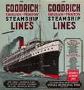
| Date: | 1926 |
|---|---|
| Description: | The cover from the 1926 schedule lists the ports of call for the Goodrich fleet and features a drawing of the "Alabama". |

| Date: | 1884 |
|---|---|
| Description: | Bird's-eye view drawing of the grounds of Villa Louis, the estate of the fur trading Dousman family. After the death of H. Louis Dousman's mother in 1882, ... |

| Date: | 1960 |
|---|---|
| Description: | Aerial view with docks in the foreground. Caption reads: "Superior, Wisconsin." |
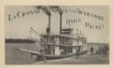
| Date: | |
|---|---|
| Description: | Steamboat on the shoreline of the Mississippi River with passengers. Caption reads: "La Crosse, Winona and Wabasha Daily Packet." |
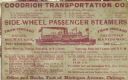
| Date: | 1878 |
|---|---|
| Description: | Advertising card for Goodrich Transportation Company listing destinations and departure times. In the center of the advertisement is a drawing of a sidewhe... |
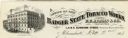
| Date: | |
|---|---|
| Description: | Letterhead of the Badger State Tobacco Works of Milwaukee, Wisconsin, with a three-quarter view of the building, men working on boats moored near the water... |

| Date: | 1873 |
|---|---|
| Description: | Map of Wisconsin showing counties, county seats, cities with populations over 3,000, and congressional districts. The map also includes rivers, lakes, rail... |

| Date: | 1875 |
|---|---|
| Description: | This map, from G.K. Warren's 1876 Report on the transportation route along the Wisconsin and Fox rivers in the State of Wisconsin between the Mississippi R... |

| Date: | 1875 |
|---|---|
| Description: | These maps, from G.K. Warren's 1876 Report on the transportation route along the Wisconsin and Fox rivers in the State of Wisconsin between the Mississippi... |

| Date: | 1875 |
|---|---|
| Description: | This map, from G.K. Warren's 1876 Report on the transportation route along the Wisconsin and Fox Rivers in the State of Wisconsin between the Mississippi R... |

| Date: | 1875 |
|---|---|
| Description: | One of a set of maps from G.K. Warren's 1876 Report on the transportation route along the Wisconsin and Fox rivers in the State of Wisconsin between the Mi... |

| Date: | 1887 |
|---|---|
| Description: | Map of the Fox and Wisconsin Rivers to accompany Reuben Gold Thwaites' Historic Waterways. |
| Date: | 1910 |
|---|---|
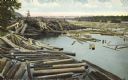
| Description: | Colorized postcard of logs floating in river, looking east between falls and railroad bridge. In the upper right corner is a large number of logging pylons... |

| Date: | 1935 |
|---|---|
| Description: | This colored road map comes with a map legend and explanation, as well as an index of cities and towns (and their populations) in Wisconsin. Information ab... |

| Date: | 1936 |
|---|---|
| Description: | This colored road map shows automobile roads in Wisconsin as well as portions of nearby states. U.S. numbered highways are shown in red, and information ab... |
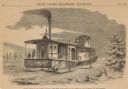
| Date: | 1859 |
|---|---|
| Description: | Engraved drawing of Norman Wiard's ice locomotive, the Lady Franklin operating on a frozen river. Male passengers and crew members are standing on t... |
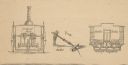
| Date: | 1859 |
|---|---|
| Description: | Cutaway details of Norman Wiard's ice locomotive, Lady Franklin sowing the stern and seating area. Also included is a drawing of the vehicle's ancho... |
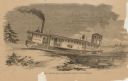
| Date: | 1859 |
|---|---|
| Description: | Engraved drawing of Norman Wiard's ice locomotive, Lady Franklin leaving a snowy riverbank and entering the frozen river. The vessel was built, but ... |
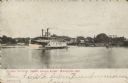
| Date: | 04 01 1907 |
|---|---|
| Description: | Text on front reads: "Steamer 'Le Fevre' Coming Through Bridge, Winneconne, Wis." A steamer passes through the "lost through truss swing bridge" over the W... |

| Date: | 1875 |
|---|---|
| Description: | One of a set of maps from G.K. Warren's 1876 Report on the transportation route along the Wisconsin and Fox rivers in the State of Wisconsin between the Mi... |
If you didn't find the material you searched for, our Library Reference Staff can help.
Call our reference desk at 608-264-6535 or email us at: