Filter: Categories of Wisconsin Historical Images
Filter: FORMAT_TYPE of prints, photomechanical
Filter: County of Grant
Filter: Categories of Wisconsin Historical Images
Filter: FORMAT_TYPE of prints, photomechanical
Filter: County of Grant

| Date: | 1869 |
|---|---|
| Description: | Birds-eye drawing of Boscobel, Grant County, depicts street names and street layouts, houses, rivers and trees. A reference key at the bottom of the map sh... |
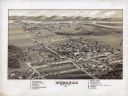
| Date: | 1875 |
|---|---|
| Description: | Bird's-eye map of Lancaster, with inset of Monument for the Soldiers of Grant County. |

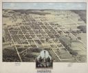
| Date: | 1875 |
|---|---|
| Description: | Bird's-eye map of Platteville. |

| Date: | 1829 |
|---|---|
| Description: | Drawing of Cassville depicting a horse cart on the river's edge, with men and boats. |
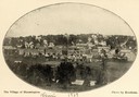
| Date: | 1873 |
|---|---|
| Description: | View of Bloomington by the pioneer photographer of the village, Frank Witcomb, sometime after 1873. There are buildings identified in the foreground on bot... |
| Date: | 1900 |
|---|---|
| Description: | Oval-framed view of the village of Bloomington. |
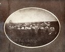
| Date: | 1864 |
|---|---|
| Description: | Oval-framed view of the village, founded by Delos W. Taft, had its name changed to Bloomington in 1867. It had been named Tafton. |
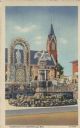
| Date: | 1937 |
|---|---|
| Description: | View of fountain with a statue of a bird on top. There is a memorial to Christopher Columbus behind the fountain, and a church with a steeple in the backgr... |
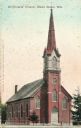
| Date: | 1900 |
|---|---|
| Description: | Caption reads: "St. Francis' Church, Hazel Green, Wis." |
| Date: | |
|---|---|
| Description: | An engraving based on a drawing by Alexander Simplot of the Platteville Brewery (spelled Plattville). It is an elevated perspective showing the main buildi... |

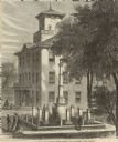
| Date: | 1909 |
|---|---|
| Description: | A Civil War Monument and fountain in Lancaster. Caption reads: "Fountain in Honor of the Boys in Blue, Lancaster, Wis." |

| Date: | 1909 |
|---|---|
| Description: | Caption reads: "Main Entrance — Hillside Cemetery, Lancaster, Wis." |

| Date: | 1909 |
|---|---|
| Description: | Exterior view of post office on a street corner. Caption reads: "Post Office, Lancaster, Wis." |
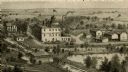
| Date: | 1868 |
|---|---|
| Description: | Elevated view of the Grant County Soldier's Monument. A group of people are standing around the monument. A large building is in the background. Caption at... |
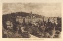
| Date: | 1910 |
|---|---|
| Description: | Elevated view of Saint Clara Academy, formerly known as Saint Clara College. Caption reads: "Saint Clara College — Sinsinawa, Wisconsin". |
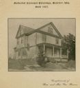
| Date: | |
|---|---|
| Description: | Methodist Episcopal Parsonage, built in 1905. Caption on print at top reads: "Methodist Episcopal Parsonage, Montfort, Wis. Built 1905." Caption at bottom:... |

| Date: | |
|---|---|
| Description: | Plan of township no. 3 north, range no. 5 west of the 4th principal meridian. |
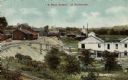
| Date: | 1915 |
|---|---|
| Description: | Elevated view of mining operations. Caption reads: "'A Busy Corner' of Platteville." |
If you didn't find the material you searched for, our Library Reference Staff can help.
Call our reference desk at 608-264-6535 or email us at: