 Filter: Categories of Wisconsin Historical Images
Filter: FORMAT_TYPE of prints, photomechanical
Filter: Community of Madison
Filter: Categories of Wisconsin Historical Images
Filter: FORMAT_TYPE of prints, photomechanical
Filter: Community of Madison

| Date: | 1910 |
|---|---|
| Description: | Map of the general plan of the district of the Four Lakes. |
| Date: | 1910 |
|---|---|
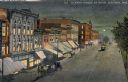
| Description: | Elevated view at night of streetcars moving along the Capitol Square on Pinckney Street. Walzinger's Drugstore is one of the prominent storefronts on the l... |
| Date: | |
|---|---|
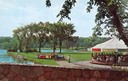
| Description: | View from a stone bridge towards Vilas Park, with children riding the carousel (merry-go-round) and a kiddie train adjacent to the lagoon. |
| Date: | 1915 |
|---|---|
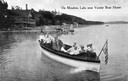
| Description: | View of a group of people in a large model launch with an American flag. Caption reads: "On Mendota Lake near University of Wisconsin-Madison Boat House." |
| Date: | 1915 |
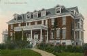
|---|---|
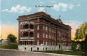
| Description: | St. Mary's Hospital soon after its completion in 1911. Caption reads: "St. Mary's Hospital." |
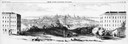
| Date: | 1858 |
|---|---|
| Description: | Panoramic sketch of State Street between North and South Halls on the University of Wisconsin-Madison campus. Published in Frank Leslie's Illustrate Newsp... |
| Date: | 1910 |
|---|---|
| Description: | View of City Hospital, which became known as Madison General Hospital and is now Meriter Hospital. It was designed by Madison architects Louis W. Claude an... |
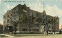
| Date: | 1915 |
|---|---|
| Description: | Central High School, designed by St. Paul architect Cass Gilbert and partially razed in 1986. Caption reads: "High School, Madison, Wis." |

| Date: | 07 17 1857 |
|---|---|
| Description: | A stock certificate of the Watertown and Madison Railroad Company, one share #85, issued to Darwin Clark for the sum of $50.00. This was signed by the rail... |
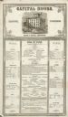
| Date: | 12 02 1855 |
|---|---|
| Description: | The Capital House bill of fare for Sunday, December 2, 1855. Proprietors were Nelson & Russell. |

| Date: | 1867 |
|---|---|
| Description: | Bird's-eye map of Madison with insets of the University, Rasdall House, Vilas House, and the Wisconsin State Capitol. View includes cattail marsh, smokesta... |

| Date: | 1885 |
|---|---|
| Description: | Bird's-eye map of Madison, State Capital of Wisconsin, County Seat of Dane County, with inset of the Wisconsin State Capitol. |
| Date: | 1890 |
|---|---|
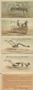
| Description: | Foldout cards in a 10-page brochure for Fuller & Johnson Mfg. Co., Ltd., manufacturers of farm implements, based in Madison, WI. The top illustration is fo... |
| Date: | |
|---|---|
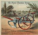
| Description: | Inside spread of 4-page advertising brochure for Fuller & Johnson Mfg. Co. Limited with a chromolithograph of a Bonanza Forge Drop planter, "The only perfe... |

| Date: | 1836 |
|---|---|
| Description: | The top map is the "Plat of Madison the Capitol of Wisconsin." The bottom map is the "Map of the Four Lake Country. Taken from the Township Maps in the U.S... |

| Date: | 1889 |
|---|---|
| Description: | Illustration of the exterior of the Fuller Opera House, which is a detail from a bird's-eye view map of Madison. |

| Date: | 1870 |
|---|---|
| Description: | Bird's-eye map of Madison. The Lakeside House resort is in the foreground, which burned in 1877, in what is now Olin Park. |
| Date: | |
|---|---|
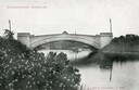
| Description: | View from shoreline towards the Steensland Bridge with a boat and passengers passing beneath. Caption reads: "Steensland Bridge, Madison, Wis." |

| Date: | 1949 |
|---|---|
| Description: | Color bird's-eye map of the University of Wisconsin-Madison as it was midcentury, with two co-eds, several photographs of campus landmarks around edges, an... |

| Date: | 1948 |
|---|---|
| Description: | Colored map with black and white photographic images in wedges at right and left sides. Map extends from Camp Randal stadium at bottom left corner, to Lake... |
If you didn't find the material you searched for, our Library Reference Staff can help.
Call our reference desk at 608-264-6535 or email us at: