 Filter: Categories of Wisconsin Historical Images
Filter: FORMAT_TYPE of prints, fine-art
Filter: Subject of warships
Filter: Categories of Wisconsin Historical Images
Filter: FORMAT_TYPE of prints, fine-art
Filter: Subject of warships

| Date: | |
|---|---|
| Description: | "Heroes of the Civil War". Engraving of eight Union leaders with decorative battlefield scenes. |

| Date: | |
|---|---|
| Description: | A lithograph of eight major generals of the Union with battle scenes decorating the center. |
| Date: | |
|---|---|
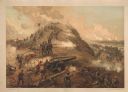
| Description: | A large color lithograph with caption of the battle in progress. |
| Date: | |
|---|---|
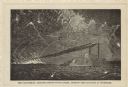
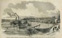
| Description: | A woodcut of "The Carondelet, leading Logan's supply fleet, running the blockade at Vicksburg." |
| Date: | |
|---|---|
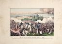
| Description: | A halftone lithograph of the Battle of Grand Gulf, Mississippi. |

| Date: | 1887 |
|---|---|
| Description: | "Kearsarge and Alabama: Hauling Down the Flag." A color lithograph published by L. Prang & Co. of Boston. |

| Date: | |
|---|---|
| Description: | "Battle of Mobile Bay." A color lithograph published by L. Prang & Co., Boston. |
| Date: | |
|---|---|
| Description: | "Capture of Fort Fisher." A color lithograph published by L. Prang & Co., Boston. |
| Date: | 1860 |
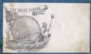
|---|---|
| Description: | A Union sailor and King Neptune stand inside a sea shell that is floating on the ocean. Between them appears a decorative circle with the Union Armada in i... |

| Date: | 1860 |
|---|---|
| Description: | Jefferson Davis, dressed as a sailor, wears a hat with the initials "JD" on it. He is holding up a wooden toy boat that flies the Confederate flag and a sk... |
| Date: | 05 31 1862 |
|---|---|
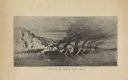
| Description: | Engraved view of the Commisary [sic] depot of Major-General Halleck's army at Hamburg Landing. |

| Date: | 1740 |
|---|---|
| Description: | Engraved and hand-colored map of the Iberian peninsula as a theater of war during the War of the Spanish Succession (1701-1714). The map is dedicated to Ki... |

| Date: | 10 1776 |
|---|---|
| Description: | Broadside map showing the British invasion of New York city in August and September of 1776. The map shows important cities, forts, roads, hills, mountains... |

| Date: | 02 1777 |
|---|---|
| Description: | Map depicting the campaigns of October and November 1776, in Manhattan, Westchester, and part of New Jersey, published only a few months after the conclusi... |

| Date: | 03 1777 |
|---|---|
| Description: | Map showing the British and Hessian attack on Fort Washington in November of 1776. The movements and fortifications of the British and Hessian troops appea... |
If you didn't find the material you searched for, our Library Reference Staff can help.
Call our reference desk at 608-264-6535 or email us at: