 Filter: Categories of Wisconsin Historical Images
Filter: FORMAT_TYPE of prints, fine-art
Filter: Subject of fields (agriculture)
Filter: Categories of Wisconsin Historical Images
Filter: FORMAT_TYPE of prints, fine-art
Filter: Subject of fields (agriculture)

| Date: | 1858 |
|---|---|
| Description: | Elevated view from bluff looking down on city, with Lake Michigan in background. Detailed foreground with two boys playing with a grounded kite, while a ma... |

| Date: | 03 24 1913 |
|---|---|
| Description: | Picnic Point from the University Farm fields, now known as Observatory Hill. |
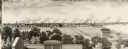
| Date: | 1880 |
|---|---|
| Description: | Illustration of an elevated view over rooftops looking towards Oshkosh. There are chimneys along the horizon with smoke rising into the sky. A river is alo... |
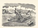
| Date: | 1877 |
|---|---|
| Description: | Letterpress print of McCormick's Harvester and Self Binder (wire binder). The grain binder is operated by a man seated on the machine and pulled by two hor... |

| Date: | |
|---|---|
| Description: | Letterpress print of a McCormick Harvester & Twine Binder. The grain binder is operated by a man seated on the machine and pulled by two horses. A farmhous... |
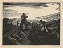
| Date: | |
|---|---|
| Description: | Engraved print depicting two people harvesting grain along a fence line in a field. One person holds a scythe while the other carries a bucket, possibly th... |

| Date: | |
|---|---|
| Description: | Engraved print of a man riding atop a wagonload of hay pulled by a horse along a road in a hilly rural area. On the left is a barn and silos. |
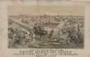
| Date: | 1893 |
|---|---|
| Description: | Lithograph of the Empire Mower and Reaper; several other reaper manufacturers and models are identified in the illustration which appears above the text: “... |

| Date: | 1937 |
|---|---|
| Description: | Pictorial map showing historical events and locations within the state of Wisconsin, as well as waterways and counties. Original caption on the bottom marg... |

| Date: | 1831 |
|---|---|
| Description: | This map shows the land that makes up Michigan, Wisconsin, Minnesota, Indiana, and parts of Canada. The Great Lakes are displayed prominently, along with s... |

| Date: | 03 1777 |
|---|---|
| Description: | Map showing the British and Hessian attack on Fort Washington in November of 1776. The movements and fortifications of the British and Hessian troops appea... |

| Date: | 1776 |
|---|---|
| Description: | Fairly detailed map of New York City and parts of Long Island. It shows streets, roads, wharves, ferries, ship yards, Fort George and the battery, public b... |
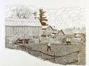
| Date: | |
|---|---|
| Description: | Pen and ink drawing farm scene of a man digging in a small, fenced-in plot of bare earth land. The scene includes two cows, two birds, a haystack, windmill... |
If you didn't find the material you searched for, our Library Reference Staff can help.
Call our reference desk at 608-264-6535 or email us at: